Category Archives: Lidar/Imaging
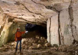
Creating Digital Twins for Water Resource Management in Caves
A substantial part of Switzerland’s water resources exist in its complex karst aquifers, a critical natural system that continues to pique the interest of researchers. At the Neuchâtel Centre for Hydrogeology and Geothermics (CHYN), a team of scientists led by Professor Phillipe Renard and accompanied by climate scientist Dr. Tanguy Racine launched an initiative seeking...
Advancing Geospatial Excellence
Advancing Geospatial Excellence: A model for public-private collaboration
How a federal liaison program and geospatial data help American agriculture
How a federal liaison program and geospatial data help American agriculture
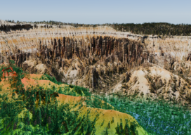
Utility Management Vegetation
Managing vegetation around America’s electric transmission and distribution infrastructure is crucial for ensuring uninterrupted power delivery. Utility Vegetation Management (UVM) is highly complex and represents a significant cost burden on utility operations and maintenance (O&M) budgets. This includes essential tasks such as tree trimming near power lines, which are critical for service reliability, grid resiliency,...

Revolutionizing Reality Capture
Imagine a world where intricate historical artifacts are meticulously preserved in digital detail, construction sites utilize 3D scans to eliminate costly errors before they happen, and filmmakers can transport audiences to breathtaking virtual environments with a click.
Technology in Action
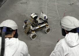
What the Lunabotics 2024 competition tells us about lidar and the future of engineers