Category Archives: GNSS/Location Tech
Your Favorite Pangaea Issues of 2018
With 2019 only a few weeks in, let’s look back at the past year and its highpoints. As your editor I took a look at the 2018 issues ranked by readership. Here’s the top three, why I think they were so popular, and the takeaways from each. Got GPS? Thank Hedy Lamarr I think this...

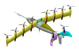
Anti-Anti-Drone Technology
Why we need it and what form it might take. I was walking down the UAS-tech-laden hall of the 2018 Commercial UAV Expo when I spied two booths touting anti-drone technology. I thought to myself, “My issue is the opposite—keeping my UAS in the air. I don’t need any help crashing it.” Yet, looking back,...
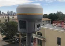
R10 Too! The R10 Model 2 Is Announced
A Flagship GNSS Rover Gets a Major Upgrade The first generation of Trimble’s flagship GNSS rover, the first R10, was announced six years ago at the Intergeo 2012 Conference and Exhibition. While updated incrementally over the years, the R10 Model 2, or R10-2, is a major upgrade. It may look the same, but that familiar...

The Rise of Value-packed RTK
Barriers are being removed for adaptable and inexpensive, high-precision GNSS. Many of you may be familiar with traditional base-rover applications for RTK such as surveying and mapping—with precision that typically comes with a large price tag. However, Swift Navigation provides a multi-frequency, multi-constellation, fully RTK-capable GNSS receiver called the Piksi Multi with a smaller price...

Got GPS? Thank Hedy Lamarr
I know what you’re thinking, and you’re right. Hedy Lamarr, the gorgeous and glamorous Hollywood star of the ‘30s and ‘40s, had nothing to do with the invention of GPS. She did, however, invent a technology that underpins almost all modern communications. Lamarr and avant-garde composer George Antheil invented and patented a technology that Bluetooth,...

How Accurate Is an RTN?
Many surveyors have realized the benefits of using real-time GNSS networks (RTN) for survey-grade positioning. Saving time, equipment, and personnel means saving project costs. The thing about real-time GNSS surveying, however, is that “rover expertise” needs to be applied in the field (not the office). Additionally, many factors involved with GNSS signalization, as well as...