Category Archives: Energy/Utilities
Robots
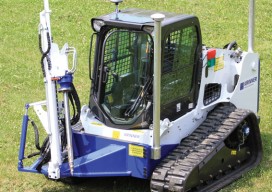
Above: GPS-controlled robots can measure a site fully automatically and precisely anchor screws for the foundation of a solar plant. Measuring and Anchoring As a child I used to watch a program on BBC television called Tomorrow’s World. Once in 1981, I sat in awe as it showed a snooker-playing robot. My dreams were filled with...

A Mapping App for Utility Assets
How a service provider for utilities implemented a mobile app to clock up efficiencies in advanced meter systems. Editor’s note: Mobile apps for asset mapping and mobile data management went from “new-cool” to essential in just a few years. In our April issue (see Mapping Peripheral) we tested a peripheral device that can add precision...

RFID
Above: RFID tags take many forms. The inside of a tag shown above—designed to attach to metal infrastructure in harsh environments, such as water pipes and valves—has a thin copper “bow-tie” antenna with a minuscule chip in the middle. It’s shown contrasted with a grain of rice. An electronic handshake has brought together the worlds...

Mapping Peripheral
A review of Trimble’s R1, a GNSS Bluetooth peripheral for mobile devices, with multiple options for correction sources. The idea of a GNSS “puck” has broad appeal: a peripheral GNSS receiver to precision-enable mobile devices such as smart phones, tablets, and a variety of purpose-built field-data-collection devices. There is a lot of functional territory between...

Maximizing the Sun
Solar energy grows in part due to aerial imaging and surveying. Solar power is booming in the United States. “Every three weeks,” President Obama said in his 2015 State of the Union address, “we bring online as much solar power as we did in all of 2008.” Geospatial technologies—especially remote sensing and surveying—play an important...

Power Scanning
An electric utility in South Africa uses mobile lidar to manage costs and improve information flow. Founded in 1923 and based in South Africa, Eskom is a large company that generates, transmits, and distributes electricity; their customers are factories, mines, businesses, farms, individuals, and even other electricity providers. In fact, Eskom provides 95% of the...