Category Archives: Cartography

Mapbox cARTography
Over the last few months I’ve just had to get my hands dirty again with Mapbox. For those who don’t know what Mapbox is, let me introduce it. Mapbox is a platform for location-based data. It allows you to host your data with them so that you can stream it into your web maps, and...

Navigating Streets with No Name
Where streets have no names, confusion creates geo biz opportunities. Those of us in the business of mapping take pride in our wayfinding skills. Yet, on a recent trip to Florence, I found myself searching aimlessly for my hotel in the city’s medieval street layout. Something was definitely wrong when I ended up between numbers...

Caretographic Representations
In parts of the world where both man-made and natural catastrophes frequently occur, how are geospatial technologies being used? And for those of us whose jobs are to create maps of construction sites and other built-up areas, how can we responsibly use the same technology to monitor destruction and wreckage? I pondered these tough questions...

Esri UK Conference 2019 Recap
Every year towards the end of May, Esri UK, the UK distributer for Esri software, holds a user conference across the road from Westminster, the home of the UK parliament (when I was there I even got to see Jacob Reese Mogg). It’s held at the QE2 centre, and there are amazing views from the fifth floor which allow...
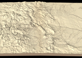
Hayden’s Survey in 3D
Above image: Hayden’s triangulation survey map is overlaid on a digital elevation model. A GIS project visualizes the fascinating triangulation network created for the historic Hayden survey of Colorado. One of the great surveyors in the American West is undoubtedly Ferdinand Vandeveer Hayden. A physician during the Civil war, he rose to be chief medical...

Who are the “Geo6” and why will this change UK geospatial?
Around the middle of 2017, there was a mumble in the geospatial industry about how the UK government was going to open up more of its geospatial data. There was even an outrageous rumor that Ordnance Survey was going to have to release its multimillion-pound product, Mastermap. Everyone sniggered but watched the news like hawks....