Category Archives: Aerial/UAS
SGM
Obtaining economical and accurate point clouds from semi-global matching. In the old days, mappers were thrilled with 30 meter USGS digital elevation models (DEMs). These were available for almost everywhere in the United States. Years later they started producing 10m DEMs, and life was really good. We had one elevation point “on the ground” every...

Legal UAS
Until the final FAA rules are in place for UAS incorporation in national airspace, the Section 333 exemption petition process is the only way to legally fly UAS for commercial applications in the United States. In late 2014, Government Accounting Office (GAO) stated, “The consensus of opinion is the integration of unmanned systems will likely...
The New Spacescape
Small satellites are changing who dominates the field of satellite remote sensing. Move over military and government policy and regulation. Make way for private companies and even the public. There are big changes afoot in the satellite remote-sensing field: improved technology as well as regulatory shifts enabling the application of this technology (see “New Markets for Satellite...

Aerial Mapping
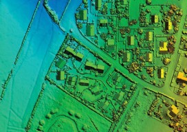
Above: Fusion of data from multiple sensors is becoming a common request from geospatial users. Here, a 10cm RGB image was fused with a classified lidar point cloud that was collected at 25 ppsm. The resultant data provides users with an enhanced ability to support a wider array of applications than each dataset used discretely. New...

UAVs for the Whole World
UAVs are fundamentally changing our world. From use in conservation, humanitarian relief efforts, precision agriculture, and a myriad of other commercial applications, more people are realizing the benefits UAVs can bring for changing businesses for the better and saving and improving people’s lives. A growing diversity of markets and applications are creating substantial opportunities for...

COAs from an Operational Applicant’s Perspective
Above picture: As COAs cross different airspace types, more coordination is required for the FAA to allows safe UAS operations in the National Airspace. By now, most everyone reading this has at least some understanding of the potential benefits an unmanned aircraft system (UAS) has on their industry. I have read publications that mention that precision...