Category Archives: Aerial/UAS

xyHt Doer: Brennan O’Neill
Brennan O’Neill Hawaiian Pacific Branch Manager for Frontier Precision Frontier Precision has been in business since 1988, selling and supporting Trimble, Nikon, Zeb-Revo, and Spectra Precision hardware and software. One thing I get a kick out of at work is, after listening to the customer, showing them the exact thing they need to do their...
Your Favorite Pangaea Issues of 2018
With 2019 only a few weeks in, let’s look back at the past year and its highpoints. As your editor I took a look at the 2018 issues ranked by readership. Here’s the top three, why I think they were so popular, and the takeaways from each. Got GPS? Thank Hedy Lamarr I think this...

Tracking Wildlife from the Sky
Above: Alan Wilson studied how cheetahs hunt with his modified aircraft. Credit: Stuart Dunn. To uncover the source of the cheetahs’ legendary hunting prowess, a researcher used a customized aerial camera to survey, film, and track their hunts. As recently profiled in a BBC documentary, Professor Alan Wilson, head of a research department at the...

Above the Mud
An orthographic image of the exposed spillway at Geode State Park in Iowa at 1″ ground sample distance. To improve water quality in a 500-acre state park, drones are key for surveying drained lakes and the surrounding watershed. Improving water quality is a key part of the Iowa Department of Natural Resources’ (DNR) mission. Planning...
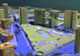
3D Cities from a Single System
Above: This screenshot is of CityMapper output. A look at the hybrid airborne system that combines lidar with oblique and nadir imagery. Over the last five years I’ve built and used a lot of 3D GIS and BIM models. Almost all of this has required the capture of stereo imagery and oblique imagery and a...
Anti-Anti-Drone Technology
Why we need it and what form it might take. I was walking down the UAS-tech-laden hall of the 2018 Commercial UAV Expo when I spied two booths touting anti-drone technology. I thought to myself, “My issue is the opposite—keeping my UAS in the air. I don’t need any help crashing it.” Yet, looking back,...