
Blog

xyHt Weekly News Links: 07/30/2021
Trimble Boosts Flagship RTX Correction Services Performance Common Ground Alliance Releases Newest Edition of Best Practices Guide North Dakota DOT Selects GeoCue for UAS Program Esri to Expand Geospatial Innovation in St. Louis Area Commercial UAV Expo Exhibit Floor Nearly Sold Out dSPACE and Cepton Partner to Provide 3D Lidar Simulation infiniDome Debuts Anti Jamming...

Senators Reintroduce Federal Land Asset (FLAIR ACT) Bill
Two senators have reintroduced the Federal Land Asset Inventory Reform (FLAIR) Act, a bipartisan bill to create a single database for lands owned by the federal government. “We cannot expect the federal government to properly manage our public lands if it cannot fully account for what it owns,” said U.S. Sen. Kevin Cramer (R-ND), a...

The Center for the Arts in Nevada County, California Optimizes Operations
Mobile LiDAR scanner Hovermap was used to conduct an internal and external scan of the facility in just over an hour to capture accurate as-builts and CAD drawings.

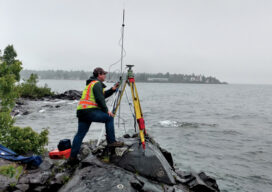
A Hard Day’s Work
I’m sure some surveyors love doing construction stakeout. Even with the advent of GPS machine control and the associated modeling that goes with that type of work, there are still a lot of stakes being driven into the ground. I am one who would be happy to never pound another stake. Some states require these...
Teaching the Future
A small university on Michigan’s Upper Peninsula is educating the next generation of surveyors and geospatial engineers
xyHt Weekly News Recap: 07/23/2021
Adaptive Motion Compensation: A Game-Changing Approach to Motion Compensation Hexagon Acquires Immersal EarthDaily Analytics Announces Timeline for the Launch of Next Generation Satellite Constellation AEye’s Intelligent LiDAR Now Available on the NVIDIA DRIVE New Esri Book Introduces Young Readers to Spatial Thinking
Advertisement