
Blog

xyHt August 2014
Click here to view the August issue of xyHt
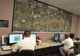
USACE GIS Cadre Mapping Team’s Future
The cadre is a team of Army Corps employees from throughout the nation who are GIS subject-matter experts. When a federally declared disaster occurs the team gets ready to deploy and can be on the ground in just hours, setting up their own equipment even before other agencies are on the scene.

Cardinal Systems’ Extraterrestrial Photogrammetry
On Earth, photogrammetrists can normally use man-made objects in their frame—such as a road of known width or a curb of known height—as scales. When none is present, they can insert such “ground truth” as needed—for example, by placing onto surveyed locations targets that will be visible in their images. On other planets in our...
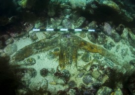
Kennemerland: Repositioning a Dutch East Indiaman
The Kennemerland is now designated as a Historic Marine Protected Area on account of the national importance of the wreck. Recently I was part of a team of archaeological divers sent to Out Skerries by Cotswold Archaeology on behalf of Historic Scotland. We were tasked with checking, updating, and geo-referencing the existing plans of the...
NC PLS Grandfathering Provision for GIS Professionals
In order to adapt to a whole new contingent (GIS), NCBELS formalized GIS Inclusion/Exclusion Guidelines for what GIS work fits under the definition of surveying in 2008 and created the Mapping Sciences Exam in 2009 as an alternative exam that focuses on areas of the surveying profession that GIS professionals would work with.
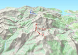
Create an Awesome 3D Map in Minutes in #QGIS
Until recently, 3D has been a bit of a gimmick to the everyday GIS user, by this I mean that it has been quite time consuming to create a GOOD 3D representation (easily) until now. I’ve used some great 3D software whilst working on survey data and also visualisation of environmental impacts, Fledermaus, ArcScene, Sketchup,...
Advertisement