
Blog

xyHt November 2014
Click here to view the November 2014 issue of xyHt
Canada’s New Vertical Datum: CGVD2013
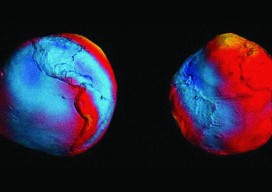
Geodesy Editor’s Note: The study of Earth’s gravity field is one of the most important aspects of physical geodesy. While seldom mentioned in land surveying text books or discussed at local surveying, mapping, or GIS conferences, it is nonetheless one of the most important issues that geospatial experts deal with on a daily basis. Changing...

Tethered Aerostats Provide Another Option in the Sky
Geospatial professionals are able to choose from an increasingly wide array of platforms on which to deploy ever more accurate and smaller sensors. Lately, unmanned aerial vehicles (UAVs) have been getting most of the buzz (pun intended). However, in many situations, high-tech versions of one of the earliest flying devices, tethered aerostats, are a better...

Setting a Standard in Railway Renewal
A highly traveled section of the UK’s West Coast Mainline rail corridor (between Warrington and Preston) required the renewal of three miles (five km) of track among four major junctions. In an intensive, nine-day continuous spell, the innovation team at Network Rail completed the work almost 16 months earlier than proposed—and avoided disrupting rail travel....

Chillon Castle: A Pix4D Sample Project
Above picture: Point cloud of full model of castle, shown from the top I wrote a review of Pix4D’s Mapper software in the November print issue of xyHt; check it out. Here’s Pix4D’s sample project to showcase the power of their software. They chose to create a model of Switzerland’s most visited site: the Chillon...

xyHt Links: 10/25/14
PacifiCAD has partnered and co-branded Eagle Point’s Pinnacle Series to deliver the PacXone HYPACK 2015 Hydrographic Training Event Optech showcasing revolutionary new sensor solutions at ChinterGEO2014 Newest SuperGIS Network Analyst 3.2 Geocue Announces Release of LP360 2014.1 Hemisphere GNSS Offers New Survey-Grade GNSS Antennas New Trimble Products Focus on Geospatial Imagery GITA is on the...
Advertisement