
Blog

xyHt Links: 12/19/14
MAPPS Urges State Legislatures to Enable the Societal Benefits of Aerial Surveys Using Unmanned Aerial Systems MicroSurvey CAD 2015 Enables Highly Efficient Drafting and Design Five New FAA Commercial UAV Exemptions — What Do They Mean? Register for TUSExpo Registration is now open for the Pacific PNT 2015 conference Automation in Trimble Positions Software Suite...
CGVD2013, Part 2
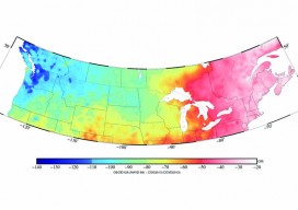
Above picture: This color contour map shows the difference between CGVD2013 and NAVD 88, especially of interest to those who work on projects along the U.S./Canada border. In part 1 of this series in xyHt’s October issue, Canada’s new vertical datum is introduced—CGVD2013— with an overview of past Canadian datums, directions during the current transition...

Creating the Futuristic Worlds of 3D
We interviewed Autodesk’s technology futurist Jordan Brandt, appropriately, in the Autodesk Gallery at their One Market offices in San Francisco. The Gallery, open to the public and the venue for monthly techie events, is a showcase for eye-popping examples of the types of innovation Autodesk’s customers have been producing for more than three decades. It...

Transformation of Observations Part 2
In my previous article in the September issue, I demonstrate one method of taking conventional/optical observations and converting them into GNSS baseline vectors. Here I demonstrate how to create a map projection system that is near the ground, and thus on the surface we survey. These map projections are commonly referred to as low-distortion projections;...
Open Source in the UK
Contrary to popular belief, it was neither the UK government nor Britain’s national mapping agency, Ordnance Survey, who started the UK open-source movement. Although open source was present and used in the UK before 2006, it was The Guardian newspaper that started a campaign called “Free Our Data,” which called for the raw data collected...
xyHt links: 12/12/14
TUSExpo 2015 2015 Esri User Conference Registration is Now Open Blue Marble Announces Advanced LiDAR Option for the Global Mapper SDK Broadcom Launches Location Hub with Galileo Support for Smartphones Leica’s GNSS Unlimited Allows Upgrades for Reference Receivers SkyTraq GNSS Receiver Module Provides Indoor/Outdoor Positioning Trimble Obtains Exemption to Operate its Unmanned Aircraft System 3D Laser...
Advertisement