
Blog
xyHt: A New Magazine
Like so many ideas in surveying, starting this magazine started over a beer at a great little Irish pub with friends, where we discussed what the landscape of surveying might look like in the not-so-distant future. I figure, during the course of almost 50 years that I’ve been a geodetic surveyor, virtually all parts of...

xyHt: What Does It Mean?
Why did we pick an obscure geodetic expression as the name of our magazine? It’s not all that obscure—it represents a foundational element requisite to nearly all human endeavor. It touches your life explicitly and in the abstract. All of the ways that humans have measured and gauged their world, each of the conventions they...
Call for Abstracts for 2015 GIS in Action!
Mark your calendars for May 4-6, 2015 and join us in Vancouver, WA at the Hilton Vancouver Hotel and Conference Center for the 2015 GIS in Action conference. This year’s conference is jointly sponsored by the Oregon-Southwest Washington Chapter of URISA (ORURISA), Washington State Chapter of URISA (WAURISA), and the Columbia River chapter of ASPRS...
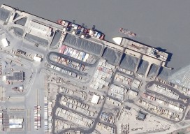
Arctic Quests
Multiple agencies and technologies merge to map a historic region of the Canadian Arctic. Adapted from the academic paper, “Arctic Charting and Mapping Pilot Project 2: Sharing Modern Technologies and Resources towards a Common Goal”, by Andrew Leyzack and summarized by Steven Keesee, with a history sidebar by Jeff Salmon.In April 2011, multiple organizations in...

Going Smaller to Grow Bigger
Editor’s note: Some of the more significant changes in workflows and data management in surveying field and office operations have come in recent years: a move to mobile, robotics, and cloud-enabled software suites. But, how has implementation played out? We offer the following case study of a forward-thinking surveying and mapping firm that has implemented...
The New Spacescape
Small satellites are changing who dominates the field of satellite remote sensing. Move over military and government policy and regulation. Make way for private companies and even the public. There are big changes afoot in the satellite remote-sensing field: improved technology as well as regulatory shifts enabling the application of this technology (see “New Markets for Satellite...
Advertisement