
Blog

xyHt Weekly News Recap: 05/24/2024
NV5 Strengthens Subscription-Based Services with Acquisition of myBIMteam Trimble Infinity Awards 18 Organizations for Excellence NOAA, Verizon Frontline Enhance Storm Damage Assessment New Mapping Technology Shows Carbon Stored In Britain’s Much-Loved Hedgerows Canadian Hydropower Producer Upgrades Timing Network Pix4D Upgrades PIX4Dcatch with Premium Augmented Reality Features ElevateUAV Summit Returns to Miami for Three-Day Drone Conference ...

Are Surveyors Professionals or Merely Technicians?
Legal Boundaries This is a question that has haunted the surveying profession for years if not decades. A second related question is: What’s the difference? Curtis Brown addressed this issue in an article he wrote that in 1961 that was published in the ACSM’s Surveying and Mapping magazine, entitled “The Professional Status of Land Surveyors.”...
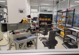
The Enduring Technology of Digital Levels Part Two
We continue our look at the foundational technology and design of precision levels for surveying with an examination of the evolution of the Digital Nivellier.
xyHt Weekly News Recap: 05/17/2024
Mapping Canada’s Captive Wildlife Problem Commercial UAV Expo Announces Path to Leadership Event Scholarship Program Peter Rabley is New CEO at Open Geospatial Consortium VIAVI Introduces Comprehensive Solution for Resilient PNT for Critical Infrastructure Emlid, Pix4D Launch Mobile Terrestrial Scanning Kit NOAA, Verizon Team Up to Advance Disaster Response Research

The Northern Hemisphere of the Celestial Globe (1515)
Maps as Art This whimsical map full of imaginary beasts and creatures is the oldest star map (or star chart) printed in Europe. It is based on the woodcuts by the great German painter Albrecht Dürer (1471-1528) who lived at a time when cartography was considered both as a work of art and a navigational...

The Growing Role of Geospatial Technology in High-Speed Connectivity for All
How mobile mapping is providing a reality capture solution for an ambitious fiber-to-the-home initiative in Ontario, Canada Investments in fiber-to-the-home or FTTH support digital equity to provide new economic, education, and public health opportunities in rural and remote areas. They also present a potential growth market for surveying companies and utilities service providers as countries...
Advertisement