
Blog
Is It Legal?
Lidar, Helicopters, and the FAA A search for recently reported case law involving the terms “FAA,” “aerial survey,” and “lidar systems” revealed a lawsuit that was decided by the United States District Court in Colorado on May 31, 2012 (see Leica Geosystems, Inc., v. L.W.S. Leasing, Inc., et al. [2012 U.S. Dist. LEXIS 75174]). Although...
Ensuring Quality
North Carolina raises the bar for orthoimage accuracy in a statewide project. Aerial mapping companies Spatial Data Consultants (SDC) and Midwest Aerial Photography each have vast experience in airborne image acquisition in support of surveying, engineering, and GIS mapping initiatives varying in scope and size. But neither firm had been involved in an image-quality validation...
The Next Generation of UAVs
The future of unmanned aerial vehicles for the geospatial profession looks to include bigger platforms for better sensors. A Drone by Any Other Name The question came up recently: “What’s the difference between a drone and a UAV?” The short answer is: none, the terms are synonymous. Which opens up a big can of alphabet...
Mapping the Damage from Superstorm Sandy
In the wake of the devastation wreaked along the East Coast by Superstorm Sandy, government agencies and private companies partnered to quickly and efficiently collect and analyze aerial data for emergency responders, relief and reconstruction workers, and the public in need. When it hit the United States as a post-tropical cyclone, Sandy had a diameter...
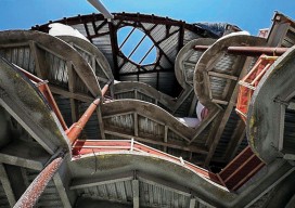
Choosing the Right Data Capture Tool for BIM
Above: This 3D image shows vertical measurements of the CUNY Applied Science Research Campus, where Bradford performed a 3D as-built measurement of all the recently constructed slab edges across six floors of the two new buildings. With the rise in demand for fast and accurate 3D construction information, laser scanning has become invaluable to many...
GIS
PSM APRIL 2013 PSM’s April issue begins the series Databased Mapping, about building the ultimate surveying database that not only stores surveying project data but also structures it to be able to produce accurate reports, analyses, and visualizations that do not depend on the way the data itself is stored.The Web of Things The theme of our...
Advertisement