
Blog
SGM
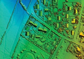
Obtaining economical and accurate point clouds from semi-global matching. In the old days, mappers were thrilled with 30 meter USGS digital elevation models (DEMs). These were available for almost everywhere in the United States. Years later they started producing 10m DEMs, and life was really good. We had one elevation point “on the ground” every...
History Corner: A New Prime Meridian Marker for Florida
If surveyors share one characteristic in general it is their perseverance in the face of adversity. In setting the initial points for the beginnings of surveys in the territories and states, many surveyors suffered hardships that only one who reads the field notes understands. The threat of annihilation from hostile natives, the dread of Yellow...
Software Review: Info-Retriever 12
Info-Retriever 12 – Office Management Software by AGT If you have struggled to find a software package for your office that meets the unique needs of the surveying and engineering profession, Info-Retriever is worth a look. Since 1985, Advanced Graphics Technologies (AGT) has been writing this office management application that brings a collection of business tasks...
Guest Essay: Modifying Our Scope of Services
Eddie Glawe is a party chief and LSIT who recently sat for his principles and practices exam for licensure in Maryland. A multi-talented kind of guy (he has even dabbled in acting), Eddie is best known and respected as a diligent surveyor who doesn’t mince words in voicing his support for our profession to maintain...
Guest Essay: Change is Hard, But It’s Not the End
Chances are that students currently enrolled in surveying and geomatics programs are familiar with the writings of Dr. Charles Ghilani, author of such reference/textbooks as Adjustment Computations: Spatial Data Analysis and Elementary Surveying (An Introduction in Geomatics). Dr. Ghilani is a professor of engineering in the Surveying Engineering Program at Pennsylvania State University. He received his PhD...
Guest Essay: A Spatial Science
This young PhD candidate from “down under” offers his insights into the role of surveying in what he sees as a boom in “geospatial sciences.” Grant Hausler is completing his PhD at The University of Melbourne and Cooperative Research Centre for Spatial Information (CRCSI). His research explores technical, commercial, and governance issues affecting the development...
Advertisement