
Blog

Surrogate UAS
Above: Hart Drobish, president of Courtney Aviation, was a contractor to the forest service flying the air tactical control platforms on the Happy Camp Complex wildfire. Additionally, Drobish served as a ground liaison contact on the project, managing the flow of infrared and visual imagery from the aircraft to the end users. Combining UAV technology...
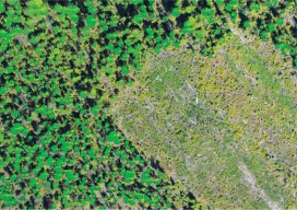
Lidar for Forestry
Above: Lidar-derived tree crowns and maximum tree-top heights are overlaid on a 20cm orthophoto. Vector-based products allow for a transition from the point cloud to GIS. A forester’s guide to understanding lidar topics, from upfront data-acquisition costs to business benefits to the path from research to operationalization. Although many lidar industry insiders never imagined the...
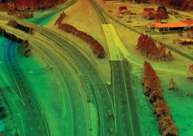
Satellite Imagery’s Impact
Above: The highest resolution of commercial satellite imagery is still more than an order of magnitude lower than the highest resolution attainable from aerial platforms. Keystone Aerial Surveys, Inc. developed this digital surface model from 1.75 cm digital imagery taken with a low-altitude flight. The resolution is sufficiently high to enable its use for mapping...

Hydrography
Above: Corporate social responsibility helps to ensure safety of the environment at a complex interactive drilling operation. Timely Delivery of Data and Products, Marine Spatial Planning, Increased Trusted Partner Resources Here’s a frameworkfor hydrography’s future. Start with the vision of a survey fleet, assisted by unmanned platforms, permanent seafloor installations, remote sensing, and trusted partner...

Unmanned Systems
Above: This robot, the BoniRob, was developed for precision agriculture by Osnabrueck University of Applied Sciences in Germany, led by Arno Ruckelshausen. Robots for Precision Agriculture, Weather Forecasting, Scientific Studies From Amazon to Google to Domino’s Pizza, unmanned aircraft systems (UAS) have been drawing significant attention in recent months. Amazon plans to launch a Prime...
Mapping the USS Arizona
A unique pro bono collaboration creates the first-ever integration of multiple technologies for mapping a historic monument. The battleship USS Arizona was bombed during the Japanese attack on Pearl Harbor on December 7, 1941. The ship exploded and sank, killing 1,177 officers and crew. It now lies at the bottom of the harbor. In 1961, Elvis Presley...
Advertisement