
Blog
MultiStation: The Multi, the Mobile, and the Modeled
Leica Geosystems’ high-profile launch of the “MultiStation” is just part of the story of the potential for new products to significantly enrich workflows for surveyors. Three related developments in workflows caught our eye recently because they may serve as a harbinger of things to come in workflow optimization, from the activities of the individual in the...
Feature: Surveying Cultural Heritage
To help preserve and manage cultural heritage sites, an interdisciplinary team is using 3D laser scanning and photogrammetry to model the sites at high resolution—meeting unique challenges with innovative techniques and creating novel opportunities for surveyors. CyArk, a nonprofit organization dedicated to digitally preserving and sharing the world’s cultural heritage, uses laser scanners to generate...
Surveyors and Surveying: Fit for Purpose
“Fit for purpose” is a phrase I’m hearing about with increasing frequency. I’d strongly suggest that you, my fellow surveyors, begin to pay attention to it. Here’s why.In the May issue I wrote about a recent situation that occurred in Virginia where two counties had decided to define their common boundary through a “GIS map”...
xyHt Heights 2015
Click here to view Heights 2015
xyHt April 2015
Click here to view the April 2015 issue of xyHt
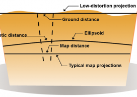
Single Transformation with ECEF
We at xyHt think this topic is one surveyors should be talking about. Instead of placing this reader’s letter to us as a comment under Dr. Ghilani’s article (linked below), we are making it a post itself to encourage discussion underneath. Editor Gavin Schrock, PLS, started us off, below. Professor Ghiliani’s article, Transformation of Observations...
Advertisement