
Blog
Software Review: Moving from Land Desktop to AutoCAD Civil 3D
Now that Land Desktop has retired, many land surveyors and engineers are wondering where to go next with their design software. This is the second of a two-part series explaining how and why two AutoCAD Land Desktop experts made the decision to move in different directions. The case for Civil 3D is made here; the...
Erick Schonstedt: The Schonstedt Legacy
For 60 years, the life work of Erick Schonstedt has been shining though the company and its exemplary instrumentation produced for surveying, geosciences, space exploration, and humanitarian causes. “MAGNETISM, n. – Something acting upon a magnet. The definition is condensed from the works of one thousand eminent scientists, who have illuminated the subject with a great white...
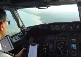
Tracking Aircraft in Flight
From surveillance methods using ground-based radar to space-based systems, it’s more complex to track aircraft than you might think. The disappearance of Malaysia Airlines Flight 370 on March 8, 2014, with 239 people on board, was both tragic and stunning. The loss of a modern commercial aircraft operating in government-controlled airspace, which remains unexplained, represents...

xyHt news Links: 3/6/15
Berntsen / Google Trusted Store Press Release Trimble Launches VRS Now Service in Oregon United Nations General Assembly Adopts First Geospatial Resolution GIS in the Rockies 2015. Registration Open. ISRO to Launch Fourth Navigation Satellite March 9 Colourcloud Set to Transform Laser Scans with Fast Point Cloud Colourisation Overlay
xyHt News Links: 04/17/15
Beginning Slate of Flyers Announced for ASPRS UAS Mapping 2015 Reno Symposium iXBlue Launches the Fifth-Generation OCTANS, Company’s Trusted Reference in Sea Navigation The Next Generation of Reality Computing Technology is Here DARPA Ocean Drone Would Lift ‘Upward Falling Payloads’ DJI Unveils Phantom 3 UAV with Indoor Positioning NovAtel Offers Relay RTK Radio Module for GNSS Receiver

RFID
Above: RFID tags take many forms. The inside of a tag shown above—designed to attach to metal infrastructure in harsh environments, such as water pipes and valves—has a thin copper “bow-tie” antenna with a minuscule chip in the middle. It’s shown contrasted with a grain of rice. An electronic handshake has brought together the worlds...
Advertisement