
Blog

25 Tips for BIM
Expert Recommendations for Better As-built BIMs Creating as-built building information models (BIMs) has been greatly facilitated by the introduction of 3D laser scanners and modeling software, but the process still has its challenges. Four experts were asked to put their decades of combined scanning and modeling experience into this list of the best tips, tactics,...

MAPPS Comments on Developing Best Practices for Use of UAS
The National Telecommunications and Information Administration (NTIA) has called for comments on UAS and privacy; their request is here:NTIA seeks comment on the process for developing best practices for commercial and private use of unmanned aircraft systems MAPPS has filed its comments, which you can find below: Formed in 1982, MAPPS (www.mapps.org) is the only...
Transformation of Observations, Part 4
Single Project Factor Here concludes a four-part series of articles about transformation of observations, spanning from September and December 2014 to March 2015. Part 1 covers how to transform surface observations into a geocentric coordinate system so that they can be compared to GNSS baseline vectors. Part 2 is about how the creation of a...
Feature: The Promise of UAS in the United States
Early adopters partner to prepare for a revolution in domestic surveying. The Unmanned Aerial System (UAS) industry in the United States is still very much in its infancy, but its potential impacts on the geospatial mapping and surveying professions are indisputable. Currently, the Federal Aviation Administration (FAA) allows UAS flights for public and federal purposes,...
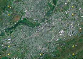
Web Waypoints: Databased Mapping
An interactive exercise merging the topo-graphical and the topo-logical Editor’s note: Just about any interaction we have with the digital world is enabled through the power of database technology: our smartphone apps, the web, shopping, work, and play. A lot of this is behind the scenes and taken for granted. Data-collection software for surveying is becoming increasingly...
Northern Lights: Mining the 55th Parallel
Tumbler Ridge, British Columbia and a bush camp in northwestern Labrador. On the surface the two communities are a nation apart, separated by more than 3,300 kms (1,865 miles) of woodland. One province flanks the Pacific Ocean as the other hugs the Atlantic. Yet geographical gap is just the tip of the iceberg of divergence....
Advertisement