
Blog

The Beaten Path
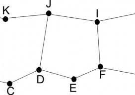
Art of Retracement With a set of eyes that had focused on survey lines through several eras, the Old Man (Glenny Dale, also known as Glutton), took one look at the cluster of three monuments along a right-of-way fence line. The site of three pins at a point where there could be only one legal...

The Clock(s) at the Center of the Universe
To provide precise global time, critical to our digital world, the United States Naval Observatory serves as the major node in a worldwide array of synchronized atomic clocks. For all but a relatively few astronomers and scientists, the universe of humans centers around our earthbound activities and our heuristic sense of time – day, night, seasons,...
I Don’t Need No Stinkin’ Statistics
Surveying Statistics, Part 1 Do you perform GNSS surveys? Do you use OPUS or perform RTK surveys simply because you don’t understand your software’s output? Do you always use the compass-rule adjustment for traverse data simply because that’s the way you have always done it? Do you ever have a situation where you know something...

A Global Geodetic Roadmap
Above: Ambassador Peter Thomson, Fiji’s permanent representative to the United Nations, presents to the General Assembly the resolution titled, “A global geodetic reference frame for sustainable development.” The United Nations takes up the call to develop a global geodetic reference frame for sustainable international relief and development. Geospatial technologies that have quickly become commonplace and essential in industrialized...

xyHt News Links: 05/15/15
Antennas Developed at SD Mines are First to Use Phase-Changing Material to Alter Shapes, Frequencies Teledyne Optech’s next-generation CMS V500 Cavity Monitoring System released GIM International Announces New Event: GIM International Summit

Easy Park Datasets
Above: Isometric view of 3D model of centralized benches, barbeques, and gazebos at Prescott National Forest. Collecting lidar data for as-built plans opt a busy national forest recreation site The Prescott National Forest (PNF) is a 1.25-million acre United States National Forest located in north central Arizona, with more than 20 developed recreation sites and an...
Advertisement