
Blog
Surveying Statistics
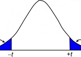
The t Distribution, Part 1 In my previous article I discuss the normal distribution and how its properties can be used to isolate blunders in observations. Recall that the normal distribution is based on an infinite number of observations. However, in practice we never collect a population of data but rather a small sample from...
Signs of Change
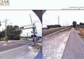
Above: This image, created with Woolpert’s online QC tool eQAS, illustrates the ability to review sign data from multiple perspectives and provides lidar and image data at the location of each sign. One collect, multiple uses. A mobile mapping system (MMS) is a versatile tool capable of creating both GIS asset inventories and design-level mapping...

xyHt News Links: 7/24/15
Trimble Unity Software for Water Utilities Adds Support for Advanced Asset Maintenance, BYOD GNSS Receivers and Esri ArcGIS Online Topcon releases ScanMaster v3.05 software upgrade
Top 5 Things to Do When You Install a New GIS Software
So, you’ve just downloaded the new QGIS release, latest ArcGIS, or maybe you are completely new to GIS and wondering how to even get started with this behemoth eating up your (or your employer’s) disk space. Having done this MANY times over the last 15 years of working with geospatial software, I’ve noticed that there...
Robots
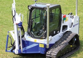
Above: GPS-controlled robots can measure a site fully automatically and precisely anchor screws for the foundation of a solar plant. Measuring and Anchoring As a child I used to watch a program on BBC television called Tomorrow’s World. Once in 1981, I sat in awe as it showed a snooker-playing robot. My dreams were filled with...

A Mapping App for Utility Assets
How a service provider for utilities implemented a mobile app to clock up efficiencies in advanced meter systems. Editor’s note: Mobile apps for asset mapping and mobile data management went from “new-cool” to essential in just a few years. In our April issue (see Mapping Peripheral) we tested a peripheral device that can add precision...
Advertisement