
Blog

The Digital Site
The complete digital site is more than just machine-controlled heavy equipment. Recent advances in heavy civil have been profound in connectivity, automation, and visualization. How long has automation played a role in heavy civil construction? As far back as the late 1980s when early GPS-guided (or informed) systems began to reach the market. But it...

xyHt September 2015 Issue
Click here to view the September 2015 issue of xyHt

xyHt News Links: 09/04/15
Sony’s Vertical Take-off Drone Aimed at Surveyors Sanborn Bolsters Industry-Leading 3-D Offerings FAA Wants Testers for UAS App Trimble Acquires Spatial Dimension to Expand its Enterprise Land Management Solutions for Government and Private Industries Leica VADASE is world’s first autonomous GNSS monitoring solution onboard a stand-alone receiver
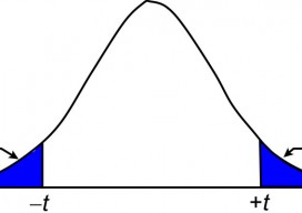
Surveying Statistics
The t Distribution, Part 2 In the previous article (July 2015), I introduce the concept of sampling distributions and the need to use these distributions to analyze small samples of data. In surveying, observing small samples is typical where angles are often observed only two or four times, and repeated distance observations simply means pushing...
xyHt News Links: 8/28/15
Juniper Systems Sees a Change in Leadership with New CEO TerraGo® Partners with CHC Navigation to Deliver High Accuracy and Improved Productivity to Mobile GPS Data Collection 100 Resilient Cities Teams with Trimble for Innovative Global Urban Resilience Initiative Trimble Launches the New ZX5 UAS! U.S. Intelligence Community Provides Innovation Exchange With Industry, Federal Civil...
Trimble Takes Flight with New Multirotor Unmanned Aircraft System
Latest Addition to UAS Portfolio Makes Working in Tight Spaces Easy Trimble announced the ZX5 Multirotor Unmanned Aircraft System (UAS), a new aerial imaging and workflow solution that captures and processes geo-referenced photo and video data for mapping, agriculture and inspection applications. The Trimble® ZX5 complements the UAS portfolio with the ability to reach smaller,...
Advertisement