Blog

Hydro Insights
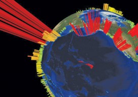
This visualization is of the high volume of commercial shipping activity into and out of ports rimming the Pacific Ocean. The data were analyzed using Esri’s new GIS Tools for Hadoop toolkit. Visualization by Mansour Raad, Esri. Available online at coolmaps.esri.com/BigData/ShippingGlobe with any browser running WebGL. Part 1: Uncharted Depths Editor’s Note: xyHt is honored to...

xyHt News Links: 9/18/15
Septentrio launches its newest receiver: the AsteRx-U Leica GS14 GNSS features new hybrid communication technology EIVA launches software solution for shallow water surveys Hemisphere GNSS’ Atlas™ and AtlasLink™ Make Trade Show Debut at InterGEO 2015 Teledyne Optech launches Lynx SG-S mobile surveying solution Topcon introduces new 3D scanners New RIEGL VZ-400i Laser Scanner FAA Issues Surdex...

xyHt News Links: 9/11/15
New mobile surveying solution from Teledyne Optech at INTERGEO 2015 YellowScan®, the lightest LiDAR for UAVs aided by the Ellipse-E miniature inertial navigation system Parsec Technologies Announces New Penta-Band LTE Antenna for IoT Applications

Capturing the Wind
A one-person crew provides foundational data for building a massive wind farm in Australia, using integrated survey technology. When you look at the commanding stature and aesthetically pleasing symmetry of the turbine towers at the Mt Mercer Wind Farm in southeast Australia, it is easy to gloss over the central role that surveying and engineering...

Geospatial PPPs
Striking the right balance in building national cadasters with private/public partnerships. Land ownership is a foundation of national economies: those who have land titles can use them to obtain credit (which is often essential to start and expand businesses), and property taxes are a key source of government funding. Therefore, authoritative and efficient land registries...

Why Your Maps Should Get in Touch with Their Feminine Side
Google does it, Apple does it, but do your maps use landmarks to improve users’ familiarity? More to the point, why aren’t popular landmarks a standard GIS dataset? For more than 10 years now we’ve known that the majority of the population use spatial recognition to navigate. When I say “majority.” I mean women and...

