
Blog
Recreating the Ordnance Survey Explorer Maps with Open Data
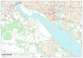
The holy grail for many (UK) map users is the Ordnance Survey 1:25,000 scale “Explorer” map. Not only are they easy to read due to the fantastic cartography used, but they also have information which is hard to source such as public rights of way, National Trust & Woodland Trust sites, even wind farms. To...

We Are Aviators First
With UAS, surveyors are becoming aviators. As we adopt new technology, we should heed old advice. I flew my first photogrammetric mission in the early 1980s while I was completing my geodesy degree during tumultuous times at my alma mater. While the rest of the world had disco fever, students at Universidad Central de Venezuela...

Indiana Jones With a Tripod
Why choose surveying as a career? Read this. My desk is a mess right now: stacks of old field books, dusty quadrangle maps, and a plumb bob serving as a paper weight for my research notes. I have to look under a pile of mining claims to find my trusty compass. I tuck the compass...

Copter Power
A UAS rotocopter pilot directs the successful imaging of a breakwater project in Costa Rica. Unmanned aircraft systems (UAS) are finding their way into geospatial applications beyond the obvious commercial topography, volumes, and inspection applications. One particular application that is poised to take advantage of the lower cost associated with UAS data acquisition is environmental...

xyHt News Links: 10/02/15
Surveying solutions from Teledyne Optech at Esri Electric & Gas GIS Conference Trimble Introduces Next Generation Indoor Mobile Mapping System for Building Interiors and Underground Structures Capturing Reality Forum reveal cutting edge conference programme MDA expands imaging modes for RADARSAT-2 for ocean applications AUVSI and 28 Organizations Mark Missed FAA Deadline for UAS Integration Leidos and Boundless...
NSPS President’s Message to the Membership
A message to the membership of the National Society of Professional Surveyors (NSPS) from the NSPS President Jon Warren, PLS To all our new members, “welcome to your National Society of Professional Surveyors (NSPS)”, and to our previous members, “welcome to your new NSPS!” And, borrowing a phrase from a past NSPS President and Chairman of...
Advertisement