
Blog

xyHt News Links: 02/19/16
End-user Requirements for Satellite Imagery/Analytics from the Agriculture, Mining and Forestry Industries Seafloor Announces the Launch of Their Autonomous Surface Vehicles u-blox brings GNSS RTK precision to the mass market TerraGo and Eos Positioning partner on next-generation GPS/GNSS solutions DJI propulsion system aimed at industry, aerial imaging New ‘laspublish’ creates Web Portals for 3D Viewing...
3D Overnight
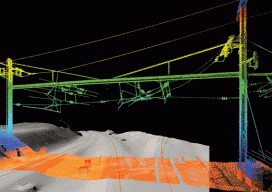
Surveying the Arsenal Interlocking rail corridor in Philadelphia safely and efficiently with mobile lidar. An old section of the Pennsylvania railroad called the Arsenal Interlocking is now one of the busiest segments of rail for the Southeastern Pennsylvania Transit Authority (Septa) regional rail system. A high volume of trains operates in this territory due to the...
xyHt News Links: 2/12/16
Hybrid concepts as ideal drive technology for commercial UAV use Autodesk’s InfraWorks 360 Offering Simplified Pix4D and Parrot Release Precision Agriculture Solutions Topcon introduces newest data controller for surveying solutions Affordable All-In-One GNSS and RTK Data Collector Verisurf X9 Software Sokkia releases SHC500 field controller an open source street level photo viewer that can be...

Advancing GNSS
A Profile of Septentrio Editor’s note: The name Septentrio may not be familiar to you, but after their formal acquisition of Altus (with which Septentrio has collaborated for a decade) you may be hearing more about this internationally recognized, high-precision GNSS developer. A leader in GNSS research and development since 1999, Septentrio has a...

Golf Simulator: Unlocking the Mysteries of the Green
A new hyper-real golf simulator app developed with point clouds calibrates golf greens so golfers can raise their mental game. Every golfer knows, you “drive for show put for dough.” Yet, once the ball is within several yards of the hole, it seems to take on a mind of its own. It speeds up, slows...

Location Technology
Terms and Uses Below is an infographic of location technology: end-use sectors, example activities, types of technology typically employed, and respective precision ranges. To help make sense of this complexity, we have developed several categories of location technology. None truly stands alone (as all employ at least some complementary technologies), but we have noted what prevalent...
Advertisement