
Blog

2022
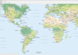
The NGS discusses the upcoming national spatial reference framework modernization. Reference framework shift happens. The National Geodetic Survey (NGS)—the federal steward of the National Spatial Reference Framework (NSRS)—is planning a major (if not fundamental) update of the framework. This pending update is common knowledge among geodetic, surveying, and other geospatial communities. Among the information circulating...
Web Mapping Part 3
Creating a Real Online Map In part 3 of this series (parts 1 and 2 are in the December 2015 and January 2016 issues), we build a web map using Microsoft Windows and Geoserver. We’ll be building this to run on the computer’s “localhost” (http://127.0.0.1), which means that you can run the web map like...

Subsidence
Do you know where your control really is? Editor’s note: The earth moves, even if we do not want it to – or we do not perceive that it does. If you are surveyor working in any part of the country your work will be subject to some degree of subsidence or deformation – be...

xyHt News Links: 3/11/16
Trimble 4D Control Software Supports IBIS-FM Radar Device for Slope Stability and Structural Monitoring in Mining TerraGo Launches On-Demand Solution for Mobile Forms, Inspections and Surveys Topcon announces new geodetic antenna Maptek modelling and exploration technology on show at PDAC Teledyne Optech Press Release: Innovative solutions for bathymetry at Oceanology International 2016 3DR collaborates with...
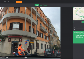
An interview with Mapillary CEO Jan Erik
Following Mapillary’s announcement yesterday, I sought to get more information about Mapillary and how they have come to be such an interesting prospect in the geospatial world. Mapillary is a pioneer in new ways to capture, share, and utilize street-level images. Yesterday I had the privilege to interview Jan Erik Solem of Mapillary to get the...

Visualizing the Perfect Putt
High-definition laser scanned topography-included in golfing greens contours books-elevates putting performance at the U.S. Open. It was two o’clock in the morning and pitch black, except for the red laser of the scanner. It pierced the darkness, accurately tracing the putting green’s profile. Michael O’Brien was enjoying perfect working conditions on the historic Pinehurst No....
Advertisement