
Blog
Demystifying Mobile Mapping
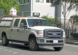
Above: A mobile mapping rig of the engineering consulting firm Tetra Tech; the crew mapped the entire 288 miles of roadways in the city of Redmond, Washington in six days of driving. A surveyor examines (and asks users a lot of questions about) the Pegasus:Two system. Editor’s note: How could measurements taken from a moving vehicle...

UAS & The Combo that Opens Access
The most logical integration of technologies for surveyors is combining 3D laser scanning with UAVs. It’s no secret that many geospatial professionals are enamored with unmanned aerial systems (UAS). For many years, the pros and cons of deploying small UAS for mapping and surveying, along with their ongoing regulatory discussions, have been well researched and...

xyHt News Links: 6/10/16
Tallysman Expands its Geodetic Antenna Line CHC launches high-end GNSS receiver for science, surveying Establishing orthometric heights using GNSS — Part 7 Topcon announces global Agriculture Group SETTOP BATTERY II: Safety and high performance for your surveying instruments. FARO Releases High-Resolution 3D ScanArm for Reverse Engineering and CAD-Based Design Applications Topcon introduces new Professional Services team...

Mentoring: A Two Way Street
As the tools of our profession have changed, it seems that the opportunities for mentoring those following in our professional footsteps have diminished dramatically. Mentoring, or the lack thereof and what to do about it, may be the most widely discussed topic in our profession these days, from discussion forums, to professional associations, to the...
3D, GIS, VR… We’re in Cloud City
When the father of GIS, the late Roger Tomlinson, first imagined a computerized system for handling land inventory mapping more than half a century ago, did he imagine that GIS would become such an integral part of our lives? At a click of a button, we can access directions to where we want to go,...

Do Your Work Right (and You Can Be ‘Smart’ Too)
Ever since I saw the phrase “smart city,” I have cringed. Not because of the term but because of what it alludes to. To me it says that we (geospatial experts) haven’t done our work right. Let me explain. From Wikipedia: “A smart city is an urban development vision to integrate multiple information and communication technology...
Advertisement