
Blog

xyHt and The First Four Ds of Construction
It is high time that xyHt gives a shout out to our new readers who have subscribed since our 2014 launch. We have gained thousands of readers in surveying, engineering, and the construction sector. This issue will be circulated broadly at CONEXPO-CON/AGG 2017, one of the largest trade conferences in the world and most definitely...
Caught Mobile Mapping
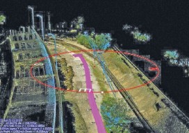
Above: Using a mobile mapping system, Construction CAD Solutions can generate high-accuracy point cloud data–in multiple views, as shown above and at left–to assist in its utility design function. Mobile mapping: A Chicago firm uses lidar innovation to survey for fiber infrastructure–for hundreds of miles. By Larry Trojak The ability to identify, accept, and then...

Surveying States: Different, Yet the Same
With the President’s Day holiday recently behind us, a day I refer to as Surveyor’s Day (think Mt. Rushmore) and National Surveyors Week starting on March 18, 2017, I can’t help but think about surveyors across the United States as a whole. Although my entire professional practice has been in California, over those years I have...

Deep-sea Mobile Mapping
We’re all familiar with lidar-based mobile mapping from ground vehicles, and most of us are aware that aerial lidar is being used effectively to do shallow-water mapping along coastal and riverine projects. Deep-water lidar mobile mapping from an ROV? Well it’s a first for me. Most all of the subsurface surveys I’ve read about were...

xyHt News Links: 2/24/17
EngineerSupply Expands With GeoMax Surveying Equipment Company EdgeData & Harris Corp Will Collaborate on Electric Utility Mgmt. Solutions Pokémon Go the Geospatial Gamechanger: Six Months Out ArcGIS Solution Provider and Esri Business Partner, GEO Jobe, Launches GIS Knowledge Base
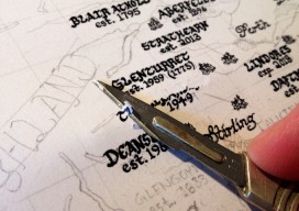
Back to the Future
An Interview with the hand-drawn map creator, Kevin Sheehan There isn’t much you can’t do with digital media nowadays, from effective maps using shadows and drop effects to using graphic-design packages to make the map “pop”—except for one thing—capturing that hand-drawn style, the way that the pen line moves in and out from the pressure...
Advertisement