
Blog

Not Everything Requires High Accuracies
How feature inspection, assessment, and reporting are now available to non-experts (and experts alike). In the early 2000s, Leon Toorenburg was in Africa mapping the locations of communications and utility towers. He was carrying a laser range finder, a camera, a GPS receiver, a laptop, and a field stick. It occurred to him that there...

Find Your Home – on Pangaea
First, a bit of “geosplaining.” When we started this newsletter we looked for a name that had a “geo” feel without having geo in the name. For those who don’t follow geology, Pangaea was the most recent supercontinent which was formed roughly 200 to 250 million years ago, according to the plate tectonics theory. Flash...

Weekly xyHt News Links: 07/20/2018
UAS Magazine Announces Preliminary Agenda for 2018 UAS Summit & Expo trajectoryXyzt GEOSPATIAL INTELLIGENCE CONFERENCE ANNOUNCED Sokkia introduces T-18 field controller with advanced performance for diverse applications A New Reality for Geospatial Professionals
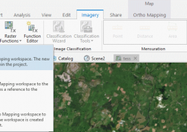
Using Ortho Imagery (Digital Aerial) in ArcGIS Pro
The new version of Esri’s ArcGIS Pro software offers the capability to use stereo imagery, something of great use to those looking to digitize and use 3D vector data. To this end, I thought I would try bringing in some stereo aerial data to see how the process works within ArcGIS Pro. Vague Knowledge At...

The Gamification of the Geospatial Industry
Why Is It Important? With huge, sprawling maps and realistic cities now appearing in our video games, it begs the question as to how these amazing cities render so quickly, yet we geospatial experts still sit waiting for 10 minutes for our software to open. For example, the notorious Grand Theft Auto: San Andreas (pictured...

CORS Map
A First for Africa Geospatial professionals don’t need an introduction to CORS. For everyone else, it’s an acronym that stands for continuously operating reference systems: geodetic receivers that log GNSS observables continuously which, when transmitted to users with survey-grade receivers, help them achieve centimeter-accuracy measurements. CORS stations have a range of about 70 kilometers (~43...
Advertisement