
Blog

What Can Spatial IT Do for You?
Helping firms meet the challenges of the global uptick in infrastructure development. Editor’s note: What is spatial IT? This umbrella term for the spatial component of the new wave of digital wizardry that’s transforming our geospatial and geomatics professions and industries can seem nebulous. xyHt has adopted the following working definition (as the term applies...

Drones over Venus
While attending the AUVSI XPONENTIAL conference last May, I spoke with the team at Black Swift Technologies, a Boulder, Colorado-based UAS engineering firm specializing in scientific platforms, and I asked them to keep me updated with their progress. I recently received the news that it has been awarded a NASA contract to develop a UAS...

Learning to Scan
An interior scan of an auditorium by undergraduate students gave them a thorough lesson. Florida Atlantic University (FAU) is the only school in the southeast that offers geomatics engineering, and the professor for the terrestrial laser scanning class, Dr. Sudhagar Nagarajan, asks a lot of his students to succeed. During this past spring semester (2018), we students had...

Weekly xyHt News Links: 08/10/2018
Latest software release from Maptek supports 19,000 Vulcan users Hexagon expands Content Program to increase coverage and access of air-borne imagery FUGRO’S NEW RAMMS TECHNOLOGY ADVANCES BATHYMETRIC LIDAR MAPPING CAPABILITIES

How Accurate Is an RTN?
Many surveyors have realized the benefits of using real-time GNSS networks (RTN) for survey-grade positioning. Saving time, equipment, and personnel means saving project costs. The thing about real-time GNSS surveying, however, is that “rover expertise” needs to be applied in the field (not the office). Additionally, many factors involved with GNSS signalization, as well as...
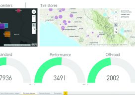
mESRIsoft
More than partners, Esri and Microsoft collaborate and combine platforms to benefit their users and the public. From their CEOs, Jack Dangermond and Satya Nadella, down to the individual developers and field sellers, Esri and Microsoft work together very closely. “We are connected at almost every level to each other’s companies,” says Lea Ann Thurman,...
Advertisement