
Blog

xyHt Magazine September 2018 Issue
Click on the cover below to view the September 2018 issue of xyHt magazine. Articles in the issue include (links will turn live throughout September): QGIS: What Is It and How Does It Work? – An introduction to QGIS by Nick Bearman, noted GIS trainer and consultant at Geospatial Training Solutions and teaching fellow. QGIS...
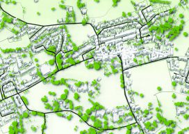
QGIS: What Is It and How Does It Work?
Editor’s Note: Nowadays everything costs, whether you are a solo practitioner, in a small business, or part of a large firm seeking to expand. You buy a new laptop, you need an operating system, then office software, then a broadband subscription; the cost keeps escalating. Are you bound to this legacy progression of costs? Not...

Weekly xyHt News Links: 08/31/2018
Hexagon Partners with Clevest to Improve Utility Field Operations Topcon announces acquisition of ThunderBuild Topcon introduces new software for UAV inspection applications Trimble Launches New Model of its R10 GNSS System for Land Surveyors The Spry: The First Waterproof Drone That Submerges, Floats Like a Boat, and Flies in the Air Geneq Inc. Announces F90...

Got GPS? Thank Hedy Lamarr
I know what you’re thinking, and you’re right. Hedy Lamarr, the gorgeous and glamorous Hollywood star of the ‘30s and ‘40s, had nothing to do with the invention of GPS. She did, however, invent a technology that underpins almost all modern communications. Lamarr and avant-garde composer George Antheil invented and patented a technology that Bluetooth,...
Weekly xyHt News Links: 08/24/2018
DJI Introduces Mavic 2 Pro And Mavic 2 Zoom: A New Era For Camera Drones Laser Technology, Inc. Announces a New and Improved TruPulse 360 Laser Rangefinder with TruVector Compass Technology DroneDeploy Releases Intelligent Cloud Photogrammetry Leica Announces the M10-P Full-frame Digital Rangefinder Camera NovAtel launches TerraStar-C PRO correction service Dstillery Launches Dscover Maps, Providing...
Weekly xyHt News Links: 08/17/2018
IrisVR Brings VR to Construction Industry with First Ever Navisworks Integration to Support BIM New Geospatial Intelligence Monitoring and Analytics Platform Delivers Superior Forestry Risk and Operational Management Blippar Launches Indoor Visual Positioning System for Enhanced Location-Based Augmented Reality
Advertisement