
Blog
QGIS Chair
An Interview with Paolo Cavallini Paolo Cavallini has been part of QGIS for as long as I can remember. Whenever I’ve had problems or made a remark on the QGIS mailing list, he has been there to help. He is everything you don’t expect a developer to be. Furthermore, he has now become chair of...

Being a Reference for Survey Exam Candidates
Why you should take the opportunity seriously. If you spend time reading almost anything regarding the state of our profession and the growing concerns regarding the viability thereof, you will often see several factors mentioned: the inability to attract young people despite our high-tech, three-dimensional suite of deliverables, the erosion/loss of traditional surveyor tasks, in...
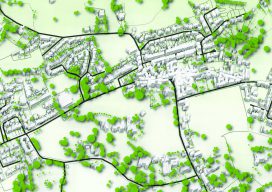
QGIS Details
How features are developed, plus details on releases, support, and plugins. Editor’s note: Tim Sutton has been a figurehead for free and open source software (FOSS), is past chair of the QGIS steering committee and is also co-owner of Kartoza. Here he kindly writes about how QGIS works on a project level from his vast...

LiDAR for Forestry
Sponsored by Green Valley Finding DBH Values from Handheld Mobile LiDAR GreenValley International’s (GVI) LiBackpack provides mobile terrestrial and handheld LiDAR solutions that allow users to efficiently capture 3D data. As part of our LiDAR in Forestry applications series we investigated the accuracy of diameter at breast height (DBH) measurements extracted from LiBackpack data using...

Geomatics STEM Outreach – NM State Prep Academy
Editor’s note: With all the talk among surveying and geospatial practitioners and the professional associations and societies about outreach, succession planning, and recruitment, it is great to see examples of action from across the country. Here is a great model for other state societies to emulate from New Mexico, courtesy of David Acosta, PS, president...
Founder of QGIS: Gary Sherman
An Interview with Gary Sherman If Roger Tomlinson is considered the father of GIS, then Gary Sherman is one of the godfathers. He started building a GIS to solve a particular problem, and it has since grown into the world’s most-popular free GIS: QGIS. Gary doesn’t often give interviews, so when he agreed to do...
Advertisement