
Blog

Who Does SUE?
Subsurface utility engineering lies at the intersection of surveying and engineering. Over the years I have had many discussions with folks in the broader engineering and survey world about subsurface utility engineering (SUE) regarding both the practice and the terminology. One of the main discussions has been whether the practice aligns more closely with engineering...

The Three Es
Above: Santiago Canyon College student Scott Givens learns land surveying with the school’s industry-leading technology. Educate, equip, and empower our apprentices Recently I accepted the position of program facilitator for the Surveying and Mapping Department at Santiago Canyon College (SCC), Orange County, California. At SCC we lead by three simple words. First we educate, then...

Interview with Esri’s Ben Flanagan
Ever wonder who makes those maps you see in the newspaper? Ben has made maps for the Telegraph, the Guardian, and BBC News, and best of all (to me) he’s from the UK! Ben is like a ninja—not many people know about him but those that do are avid fans of his work. It was...

Above the Mud
An orthographic image of the exposed spillway at Geode State Park in Iowa at 1″ ground sample distance. To improve water quality in a 500-acre state park, drones are key for surveying drained lakes and the surrounding watershed. Improving water quality is a key part of the Iowa Department of Natural Resources’ (DNR) mission. Planning...
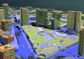
3D Cities from a Single System
Above: This screenshot is of CityMapper output. A look at the hybrid airborne system that combines lidar with oblique and nadir imagery. Over the last five years I’ve built and used a lot of 3D GIS and BIM models. Almost all of this has required the capture of stereo imagery and oblique imagery and a...

xyHt Magazine December 2018 Issue
Click on the cover below to view the December 2018 issue of xyHt magazine. Articles in the issue include (links will turn live throughout December): 3D Cities from a Single System – a look at a unique hybrid airborne system that combines lidar with oblique and nadir imagery. Who Does SUE? – Subsurface utility engineering isn’t really engineering;...
Advertisement