
Blog
Siotasia Malalo
Graduate Surveyor, Ministry of Lands Survey & Natural Resources Nuku‘alofa, Tonga In April of 2018, Tonga’s Prime Minister launched the world’s first regional strategy for surveying and geospatial capacity development. A regional consortium of Pacific maritime countries and territories including Tonga, Samoa, Vanatu, and many more face common challenges in geodetic issues; surveying, mapping, land...
OS Zoomstack – the Gift that Keeps On Giving
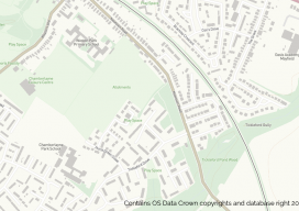
On July 17 2018, Ordnance Survey (OS), the United Kingdom’s national mapping agency, released a trial of a product called “OS Zoomstack.” At the time many overlooked it, as Ordnance Survey makes lots of their data over 1:5000 available for free. I have to admit I was one of them. In August of last year,...
María Elena Osorio Tai, PhD
Professor, The National Autonomous University of Mexico (UNAM) Mexico City, Mexico María Tai’s nominators characterize her as modest as she walks from her research office at the Atmospheric Sciences Institute to the engineering department at UNAM (to teach GIS, numerical and mathematical modeling, and geodesy), but they say that behind her demeanor is a great...
Christopher F. Jordan, PLS
Project Surveyor & UAS Pilot, McGill Associates, P.A. & Geomatics Adjunct Instructor, Asheville-Buncombe Technical Community College North Carolina, USA Chris Jordan is a pioneer in drone technology and has honed his skills over the past decade to catapult his company to being a leader in the surveying industry in his area. Jordan is licensed in...

Weekly xyHt News Links: 02/15/2019
Trimble Launches Division Dedicated to Advancing Commercial Map-Centric Technology International LiDAR Mapping Forum Draws 1,682 Professionals for Education, Networking, and Geospatial Technology NavVis now uses SLAM to automatically remove point cloud artifacts UgCS introduces Telemetry Sync tool for DroneLogbook MAPPS Presents the 2018 Geospatial Products and Services Excellence Awards SimActive Expands its Partner Network for...
Emily Tidey
Lecturer, Hydrographic Surveying, Otago University Dunedin, New Zealand We received a record number of nominations for geospatial professionals in New Zealand this year—and all were women! While difficult to choose from among the candidates, Emily Tidey stands out as an educator and specialist in the essential (but often overlooked) surveying discipline of hydrographic survey. Maritime...
Advertisement