
Blog

Weekly xyHt News Links: 05/24/2019
Topcon introduces real-time reality capture solution Bentley Systems Announces the Acquisition of Keynetix, Provider of Geotechnical Data Management Cloud Services
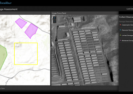
ArcGIS Excalibur
A new “un-GIS” GIS tool enables access, measurement, analysis, and markup capabilities for images – for everyone. Many years ago, during the era of cinematography and good old-fashioned film, they used to edit movies by cutting the film with a pair of 9-inch scissors; these were called “excalibur.” This sets the scene for the new...

The Fixed-Wing Fix
Why a multi-discipline firm chose a fixed-wing sUAS solution for large-scale surveying and quantities for mines and quarries. Editor’s note: When xyHt began covering the rise of sUAS for AEC applications years ago, many of the early successful entries into the burgeoning sUAS market were fixed-wing craft, like those from Gatewing (that we wrote about...
Weekly xyHt News Links: 05/17/2019
Attollo Engineering introduces WASP-200 laser rangefinder Orbit GT launches 3D Mapping portfolio v19.5 and QGIS plugin update SimActive Software Enables Processing of Wingtra Drone Data

Rocketry Revolution #4: Air Breathing Rockets
In a Pangaea issue entitled Revolution #3, I laid out the latest three revolutions in rocketry. Reusable rockets like SpaceX and Blue Origin, Air-launched rockets like Stratolaunch and Virgin Orbit, and Drone-launched rockets as exemplified by the Aevum Raven. Each revolution is designed to make space more affordable and accessible. Reusable rockets are obviously more...

Understanding GNSS Pt. 2
Vertical Datums Part 1 covers ellipsoids, datums, and realizations and is in the April print issue. This final part covers vertical datums. From my previous article: One of the most important things to understand when it comes to using survey-grade GPS systems is the difference among the many datums, reference ellipsoids, and coordinate systems that...
Advertisement