
Blog
Using Object Detection for More Accurate Live Mapping
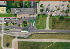
Almost a year ago today I was in a meeting where someone was telling me that the project we were working on needed to use LoRa positioning so that diggers and trucks could be tracked on a real-time map. I am not at liberty to give you my full response, but my professional response is...
Creating a Web Map Using Mapbox
This blog is born out of pure frustration and my competitive nature. When I was looking at web mapping libraries, I looked at Mapbox and thought, “That will be easy.” Three days later I was pulling my hair out—then the next day I was smiling and happy. You see, Mapbox is similar to Leaflet in...
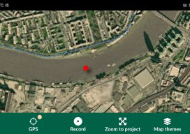
Open Source Field Capture
Recently I’ve been doing a bit of GIS training with environmental companies, mostly to help them make the move to open source software. You see, a few companies out there have propriety software licenses that are due to end, but the companies can’t justify the renewal when all they do is draw boundaries on a...

From Down Under to the Skies Over North America
As aerial firms evolve and expand to provide imaging as a service (IaaS), the next step is 3D data services. A prominent Australian aerial services company, with success in the 3D data market, is eyeing an expansion into North America. Aerometrex Pty Ltd.—not affiliated with Aero-Metrics or Aerometrics—is a prominent aerial imaging, remote sensing, 3D...

Weekly xyHt news links: 2/21/20
Leica Geosystems brings the world’s first MultiStation to the next level Leica Geosystems announces new most accurate total station LAND INFO Announces 5G Wireless Mapping Team in Europe
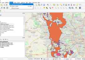
Creating a Web Map Using QGIS2Web
Almost two years ago to the day I wrote Webmapping 3.5 in which I did a walkthrough of QGIS2Web. Since then, QGIS has grown up, and so has QGIS2Web. In the original blog, I discussed how you could use OpenLayers and Leaflet as basemaps. Now you can use Mapbox, too. The layout is improved and...
Advertisement