
Blog

A New Dawn for 3D Ground Penetrating Radar Arrays
I was first immersed in ground penetrating radar (GPR) as a PhD student at Lulea University in northern Sweden in the mid-1990s, and I immediately fell in love with the technology. I love the ability it gives me to see hidden things so quickly and elegantly. I also love the notion that the equipment is...

Trimble R12i: The Next Evolution of GNSS Solution
The new Trimble R12i GNSS receiver marks the latest addition to its Global Navigation Satellite System (GNSS) portfolio. The Trimble R12i incorporates robust tilt compensation to increase productivity for land surveyors. The Trimble R12i incorporates Inertial Measurement Unit (IMU)-based tilt compensation using Trimble TIP™ technology, which enables points to be measured or staked out while...

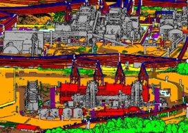
xyHt Magazine Digital Edition: September 2020
Click here, or on the cover to the right, to view the September 2020 issue of xyHt magazine. Articles in the issue include: (Links will turn live throughout September, as they are reposted here on our site blog!) Safety First: Using Small Drones to Map Unsafe Sites: Traditionally, photogrammetry based on aerial images and stereo...

Army Corps’ (JALBTCX) data improves coastal projects
In a hotel conference room on Long Island, New York, a team of experts is processing data and information on computers. Alongside them is a large display monitor that is projecting the information. The team is the Joint Airborne Lidar Bathymetry Technical Center of Expertise (JALBTCX). “It’s a beautiful thing. On the screen they are...

xyHt Weekly News Link: 08/28/2020
UAS Mapping: Where is it Heading? FARO Acquires ATS AB Ericsson and UNICEF launch global partnership to map school internet connectivity
GPI’s Advanced Geospatial Solutions for High-Altitude Mapping Projects
An established user of RIEGL airborne, mobile, and terrestrial sensors and systems, GPI Geospatial, Inc. (GPI) has added the VQ-1560 II to our toolbox of advanced digital sensors to further expand our capabilities.
Advertisement