
Blog
The Early Days of 3D Scanning: Part 8
In multiple ways, 1999 turned out to be a pivotal year for Cyra Technologies and for 3D laser scanning, in general.

senseFly Expands its Line of Fixed-Wing Mapping Drones
A mapping drone in the $10,000 price range might sound like one of those things that’s too good to be true. And up until now, maybe it was. A Swiss company called senseFly, a global leader in fixed-wing mapping drones, has expanded its flagship eBee X drone solution with the launch of eBee Geo. The...

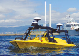
AUVs: Crucial to Seafloor Mapping Effort
In 1775, in Saybrook, Connecticut, the brothers David and Ezra Bushnell built Turtle, a little egg-shaped wooden submarine held together by iron straps, with a 30-minute air supply. The next year, in New York Harbor, Turtle engaged in the first naval battle in history involving a submarine. The first autonomous underwater vehicles (AUVs), undersea systems...
All Hands on Deck
Mapping the entire U.S. seafloor is an epic task. The country’s new national hydrographer says it can be achieved by coordinating efforts and using the latest technology.

xyHt Magazine Digital Edition: February 2021
xyHt‘s February issue focuses on hydrography and the quest to map America’s coastlines and ocean floor.

xyHt Weekly News Links: 01/29/2021
ASPRS 2021 Conference Goes Virtual Ghana Launches National Map of Forests and Land Use Big Changes to Drone Regulations by FAA Coming
Advertisement