
Blog

Drones in School
STEM education is preparing the next generation of workers for exciting careers in technology-related fields.
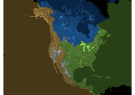
How Our Continent Drains
Robert Szucs is a digital cartographer turned artist who saw the potential to turn nature’s patterns into contemporary artwork. This ocean drainage map was a months-long project, that included “a ton of manual work,” including cleaning data, figuring out how to categorize millions of lines into a handful of ocean drainages, and then zooming in...

xyHt Weekly News Recap: 02/09/2024
Bluesky Aerial Photos at Heart of New Met Police Mapping Tool Hyperspectral Insights to Understanding the Earth Digital Construction Week Set for June in London TCarta Plans Bathymetric Mapping Workshop for Jamaica Canadian Hydrographic Conference Set for May in Newfoundland YellowScan Launches Bathymetric Lidar System Techtree Unveils ‘AROUND,’ A New Era in Geospatial 3D Visualization ...

Preserving the World’s Cultural Heritage
Scanning the ruins of a castle in Romania will help preserve the country’s past and the literary myth of Dracula

GPS Finds Its Way into the Future
As the pioneering satnav program celebrates half a century of success, it must overcome setbacks to its modernization plans in order to pull off a new era of global PNT leadership

xyHt Digital Magazine: February 2024
xyHt magazine’s February 2024 issue is takes a look at scanning and the future of GPS as it turns 50 years old. As always, if you don’t have a subscription to our print edition, or if someone else in the office has snaffled your copy, don’t fret, here is the digital edition. Click here or on...
Advertisement