
Blog

xyHt Digital Magazine: July/August 2024
xyHt magazine’s July/August 2024 issue focuses on surveying and mapping, with an in-depth look at a map maker of the future and a profile of up-and-coming Stonex. As always, if you don’t have a subscription to our print edition, or if someone else in the office has snaffled your copy, don’t fret, here is the digital...

Geospatial Tech Reaches the Olympics
Are you watching the most important global sporting event this month in Paris? Then expect not only the world’s best athletes competing for the podium, but also the best of GIS and Digital Twin technologies applied in a sporting event at a grand scale. British company OnePlan is the official digital twin and mapping partner...

xyHt Weekly News Recap: 07/19/2024
New Book by Jack Dangermond Explores Creating a Better Future through Modern GIS Get the Best Rate for Trimble Dimensions Terradepth and Hypack Partner to Bring Hydrographic Survey Data Processing to the Cloud Skyfront Launches Water-Cooled Drone for Desert Operations The Geospatial Commission’s National Underground Asset Register Wins Digital Innovation Award 5 Questions for Surveyors...

It’s a Small (Sensor) World
The fascinating emerging world of geophysical and geological exploration with drones For the last 10 years we have seen more and more applications adopting uncrewed aircraft or drones and adding them to their workflows to expand businesses and offer more versatility to their customers. But like in every other new technology, adoption is not uniform,...
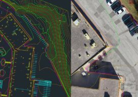
Drone Processing Services: The Importance of Keeping the Human in the Loop
Using a drone processing service can make firms, large and small, more competitive. AI is working wonders for specific steps, but can’t do it all. Vendors and users are finding out how imprtant the human elements is. Drone-based aerial mapping and surveying has evolved, over this first decade of adoption, to include a significant amount...

Shining a Light Into Black Boxes
AI-infused 3D modeling of substations, pump houses, and other facilities offers utilities immediate benefit By Ben Dwinal Using advanced GIS systems, utilities can create detailed infrastructure models that enable them to deliver services to residents more efficiently and safely. These models include highly granular data about the networks of lines and pipes that deliver electricity,...
The Best Maps Are Not Behind Us
Professional cartographer Evan Applegate shares his mapmaking process, including what’s inside his toolbox. He also tells us why in-person feedback is important to become a better mapmaker.
Advertisement