All posts by Nicholas Duggan FRGS Cgeog (GIS)

Map Making: “Can I have a map?”
“Can I have a map?” How often do you get someone ask, “Can I have a map”? I have nothing against making maps; in fact I like it so much that I have made a career out of it. Not just any map either, I’ve made maps for the nuclear, environmental, government, renewable energy, offshore...

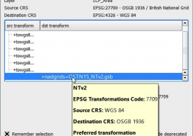
Using OSTN15 with QGIS
As you may be aware, the United Kingdom has a new transformation model that is OSTN15. But why? What does it mean to the geospatial community? Without being too nerdy, tectonic plate movement means that the “model” surface (the geoid) is slowly moving away from being the best fit for the coordinate system. It has...

Layla Gordon, Ordnance Survey Technology Laboratory Engineer
What is the Ordnance Survey Technology Laboratory? I managed to get an interview with one of the UK’s national mapping agency’s engineers, Layla Gordon, who has been working on some interesting geospatial tech. ND: How did your education lead you to OS (Ordnance Survey) and geospatial? LG: Back in 1994 I was doing a degree...

The Problem with QGIS and csv Files
Last month I was at the Maptime in Southampton (UK), helping QGIS new users with how to join tables and map EU referendum maps, when I came across an issue with something on QGIS I hadn’t spotted in the last *ahem* years of using it. When you drag and drop txt, csv, or other delimited...

Pokémon Go Leads the AR Revolution
Six months ago when I claimed that augmented reality was the future of GIS and geospatial services, it was met with a few sniggers. This week has seen the arrival of Pokémon Go, one of the most popular games to hit the mobile phone market, and yes, it is augmented reality and yes, it is...

Trolling: Always Get Independent Advice & Avoid the #geotroll
Ever since I started tweeting and blogging, I’ve received messages about using certain software, or how expensive a software is, or sometimes threats over my choice of software. It falls on deaf ears; I am independent. ANY geospatial software, no matter cost or design, is worth considering to some respect. Sure, some may meet your...
