All posts by Marc Delgado, PhD

Water from the cloud
Water utility companies are tapping into geospatial cloud computing to map their infrastructure, streamline workflows, and enhance customer services
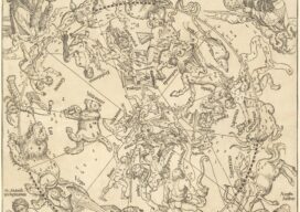
The Northern Hemisphere of the Celestial Globe (1515)
Maps as Art This whimsical map full of imaginary beasts and creatures is the oldest star map (or star chart) printed in Europe. It is based on the woodcuts by the great German painter Albrecht Dürer (1471-1528) who lived at a time when cartography was considered both as a work of art and a navigational...

Rolling Along Virtual Highways
Urban mobility in Europe gets a much-needed boost as cities develop digital twins for their road networks

GPS Finds Its Way into the Future
As the pioneering satnav program celebrates half a century of success, it must overcome setbacks to its modernization plans in order to pull off a new era of global PNT leadership

Mapping for a Good Cause
When humanitarian emergencies strike, these volunteers are ready to share their geospatial skills and help communities map their way out of crisis. You, too, can lend a hand. After Cyclone Idai made landfall in Mozambique in the middle of March 2019, it left behind more than 1,000 casualties, miles of damaged roads, and ruined at...

A Breath of Fresh Air
To improve urban air quality monitoring and help keep their citizens healthy, cities around the world are now combining traditional data capture techniques with geospatial technologies. If you happen to be driving or walking around Washington. D.C., this past summer, then there is a good chance that you crossed paths with one of the blue...