All posts by Gavin Schrock

XR – A New Mix
Mixed reality for infrastructure and geospatial takes a huge leap forward with the announcement of the HoloLens 2, SYNCHRO XR, and the XR10. This might sound a little cliché, but forget everything you knew about Microsoft’s HoloLens. The new model makes the first model seem like a toy (albeit a very cool toy). A not-so-surprising...

GPS Week Rollover – Don’t Panic (Update 3/28/19)
Updated March 28th, 2019: Unavco, the science cooperative that supports such projects as the Earthscope PBO GNSS and geophysical senor arrays, has launched a comprehensive WNRO page that addresses many of the receiver types they have deployed and includes some of their own tests. Updated March 26th, 2019: Trimble and Topcon have added updates to...

Spencer Disque
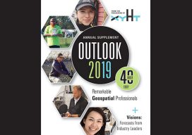
Systems Engineer, Sigma Space Corporation Washington, D.C., USA Spencer Disque has been with Sigma Space Corporation since 2009. Starting as a mechanical engineer, he designed airborne and spaceborne science instruments for NASA projects and supported them for field campaigns. He also supported design and flight testing of single photon lidar (SPL) in the infancy of the program. Over...

Siotasia Malalo
Graduate Surveyor, Ministry of Lands Survey & Natural Resources Nuku‘alofa, Tonga In April of 2018, Tonga’s Prime Minister launched the world’s first regional strategy for surveying and geospatial capacity development. A regional consortium of Pacific maritime countries and territories including Tonga, Samoa, Vanatu, and many more face common challenges in geodetic issues; surveying, mapping, land...

Emily Tidey
Lecturer, Hydrographic Surveying, Otago University Dunedin, New Zealand We received a record number of nominations for geospatial professionals in New Zealand this year—and all were women! While difficult to choose from among the candidates, Emily Tidey stands out as an educator and specialist in the essential (but often overlooked) surveying discipline of hydrographic survey. Maritime...

Surveying Mentoring Program – Arizona
A new land surveying mentorship program is launching in Arizona. “Tell me and I forget, teach me and I may remember, involve me and I learn.” ― Benjamin Franklin The Launch In 2019, the United Surveyors of Arizona, a member-driven non-profit, is developing and facilitating the first ever officially sanctioned surveying mentorship program in Arizona....
