The real-time evolution of the direct georeferencing UAV ecosystem
By Joe Hutton
While mapping using uncrewed aerial vehicles (UAVs or drones) has proven to be a relatively cost-effective method to collect high-accuracy spatial information, there are still a number of bottlenecks that make them tricky to use.
 These include the complexities and cost of acquiring, setting up and surveying with a global navigation satellite system (GNSS) base station and ground control points (GCPs); dealing with unreliable differential corrections being sent to the drone; mixed datums between base station coordinates and GCPs; the awkward workflow steps of having to retrieve recorded base station data and process that data with the recorded GNSS data in the drone; having to deal with the increased cost of long base to drone separations for Beyond Visual Line of Sight (BVLOS) mapping; and the list goes on.
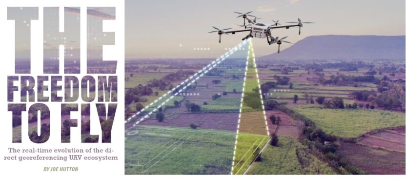
Given these challenges, the ability to fly anywhere, anytime, and to efficiently and quickly deliver high-accuracy, reliable map products literally with a push of a button may seem like a far-fetched dream.
However, the technology to enable these capabilities is fast emerging. Current advancements are focused on embedding compact direct georeferencing (DG) systems comprised of survey-grade GNSS and inertial hardware that deliver real-time centimeter positioning and highly accurate roll, pitch, and heading measurements using satellite-based GNSS corrections to enable “mapping anywhere” with little or no ground infrastructure. Not only can such DG systems enable mapping to be done with no or at least fewer GCPs, they enable the integration of camera, lidar and hyperspectral sensors into single mapping payloads with real-time or in-the-field generation of map products.
The combination of these features, with the addition of improved in-field capabilities and licensing, opens the door for smaller, lighter, higher performing solutions and real-time, in-the-field actionable data.
Attitude Adjustments
Whether direct or indirect, georeferencing is required to geocode data collected by cameras, lidar, and other sensors to create maps and hence geospatial information. With UAVs, the data can be collected at a higher resolution and more quickly than from traditional ground collection methods. This sets the expectation for faster, more accurate data generation.
However, if I can fly the drone and capture the data so quickly, why does it take so long to generate the information I am after?
Traditional ground-based surveying has long used a technique for improving positional accuracy called differential GNSS positioning, which is precise to the centimeter level and repeatable. Known in real-time as real-time kinematic GNSS or RTK, corrections are derived by calculating the positional discrepancy between a nearby base station, whose position is known, and the roving GNSS receiver.
These corrections are then used to adjust the position of the roving receiver. The base station is set up locally by a user and the corrections are transmitted via a radio link to the rover or provided via IP protocol as a service from various providers who set up their own network of receivers (referred to as a Virtual Reference Station or VRS). Given the success of RTK for ground-based surveying, it is only natural that this technique be tried for high-accuracy mapping on UAVs.
However, using RTK on UAVs has proven to be tricky and difficult to scale. Setting up a base station and surveying in its coordinates can be complex and time consuming, especially if moving from site to site. Transmitting corrections over a radio link to the drone is not always straightforward and can result in intermittent data or delays that reduce accuracy. Adding to the complexity, many regions are not covered by an existing VRS.
Another fundamental issue is that the accuracy of differential GNSS is contingent on the distance between the drone and the base station—the closer, the better. With new regulations allowing UAVs to fly BVLOS, they can easily travel far enough from a base station to the point where the corrections are no longer providing high enough accuracy. To get around this limitation, multiple base stations are required, which increases cost and complexity.
Making matters even more complex is that each set of RTK corrections is tied to the coordinates and datum of the base station they were derived from. If these are not known or are not accurate, the end product will have errors.
 Some of these issues can be mitigated by using a post-processed differential GNSS technique called post-processed kinematic GNSS or PPK.
With PPK, instead of processing the data from a base station in real-time, which requires sending the corrections to the drone, the base station data is logged along with the GNSS data in the UAV and post-processed. While this gets rid of the complexity of a real-time radio link and has the advantage of being able to process the data forward and reverse in time for better accuracy, it still has the baseline limitations associated with differential GNSS using base stations.
So, will accurate mapping with UAV ever be truly “push button?” The answer is yes, by incorporating next generation GNSS correction technologies that are evolving to replace traditional differential GNSS and RTK. These technologies involve using multi-frequency, multi-constellation GNSS signals and global reference stations operated 24/7 around the globe to measure, model, and correct the entire GNSS signal chain no matter where you are on or over the surface of the earth. Such a technique is referred to as precise point positioning or PPP.
The PPP Advantage
Advanced PPP solutions such as Trimble® CenterPoint® RTX, have quickly evolved in land-based surveying to become a highly accurate alternative to RTK, and with the latest algorithms and GNSS constellations, have now become ideal for use with UAVs. Convergence times (the time it takes for a PPP solution to achieve full accuracy) are now low enough such that centimeter level accuracy can be obtained on short UAV flights with as little as a 10-minute duration. And with the ability to obtain the corrections directly from the L-band satellite, it is a perfect technology for BVLOS UAV mapping–all without base stations.
Trimble RTX technology has been integrated for use with UAVs in real-time on DG systems containing small, state-of-the art GNSS and inertial hardware (e.g., Trimble APX), and in PPK-based solutions (e.g., Applanix POSPac PP-RTX and ApplanixPPK).
The addition of an inertial measurement unit (IMU) enables UAVs to directly measure the position and orientation of an airborne mapping sensor, such as a digital camera or laser scanner. Adding a correction service to the mix makes it easy to collect accurate data quickly for in-field georeferencing and map production.
There’s a great need for cost-effective, quick answers, whether it’s progress on a construction site or measuring stockpiles. Many users are asking for the ability to fly higher, fly longer, and get higher accuracy, all in a small compact format, without base stations–and with faster (real-time) processing capabilities.
 In the current environment, customers are waiting too long to use UAV-gathered data in an actionable way. The familiar UAV workflow–set up base stations, develop a plan, fly, download/upload data, go back to the office, post-process, fix datum issues, and generate the map–is not effective for many applications.
With Trimble RTX the time to an answer is dramatically reduced. For example, DroneDeploy, a U.S.-based company focused on reality capture using photogrammetric drones, has integrated the Trimble Applanix post-processed RTX PPK solution directly into their cloud-based mapping solution. Now, instead of dealing with base station set up, survey, and extensive GCPs, users can simply upload their drone imagery into the DroneDeploy cloud, push a button, and receive back a high accuracy map product georeferenced in a consistent datum. The vision to fly and process data all at the push of a button is already here.
On the lidar front, payload integrators such as GeoCue are now using Trimble APX DG systems with RTX in real-time to generate fully georeferenced point clouds that can be transmitted to the ground or loaded into exploitation tools upon landing. Again, without a base station.
Real-Time Intel
How does DG evolve? One of the key advancements in DG has been greater integration to improve accuracy, efficiency, and ease of use by getting rid of the known pain points. The latest UAV mapping solutions incorporate a compact single board GNSS/inertial navigation system (INS) with next generation IMUs, as well as lidar solutions that can fly higher–and thus require higher accuracy.
In addition, the inertial hardware is increasingly mature (and cost-effective), which allows for better performance in a smaller form factor at a lower price point. This capability makes it possible to assign a geographical location on the earth to a pixel from a camera image or a digital point from a laser, with little or no ground control or any additional measurements referencing the ground. And often overlooked, that single consistent datum offered by Trimble RTX removes the ambiguity associated with RTK and PPK.
In the past, RTX-type solutions have not been accurate enough or practical enough for many potential UAV applications. However, with current advancements, it has reached the level of maturity that operators truly can push a button and get results in the field. A UAV operator can drive to a jobsite, launch the UAV, map the area of concern, and then see and validate high accuracy data while still in the field.
One other area of advancement that will greatly simplify UAV-enabled data gathering is in the way of software licensing. In conventional practice, post-processing is done through a desktop application with desktop licensing. Whether perpetual or term license management, it can be a cumbersome arrangement. In some cases, organizations like Trimble are shifting from desktop licensing to real-time subscriptions directly within the hardware, thus simplifying ongoing access and renewal for customers.
Stay tuned. The UAV-enabled mapping environment is changing rapidly—and very soon you will be able to fly farther (no base stations) with greater accuracy and the addition of real-time intelligence.
Joe Hutton is director of airborne products and inertial technology at Trimble Applanix.