
The fascinating emerging world of geophysical and geological exploration with drones
For the last 10 years we have seen more and more applications adopting uncrewed aircraft or drones and adding them to their workflows to expand businesses and offer more versatility to their customers. But like in every other new technology, adoption is not uniform, and some sensors are more easily miniaturized than others. That explains why photogrammetry was an almost immediate adopter of small drones and why geophysical and geological sensors have lagged considerably over the years.
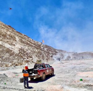
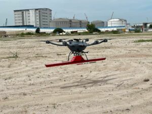
Drone Matrice 600 Pro and GPR Subecho 70 en Faena Minería en Chile
Now companies are developing electromagnetic sensors that are wonders of miniaturization. In parallel with smaller sensors, uncrewed aircraft manufacturers have managed to design and build better drones with larger useful payloads and longer flying times, which combined with smaller and lighter sensors have opened the door to a new industry: geophysical exploration with non-piloted aircraft.
We searched long and wide for a company that has made the transition from traditional aircraft to drone prospecting and found Geodia Industries, an international company with offices in Dubai, Guyana, Colombia, and allied partners in Chile, India, Saudi Arabia, and Africa. We had the opportunity to sit down with its founder and CEO Jorge Negrette for a fascinating interview that opened a window into a different world of geological and geophysical prospecting with non-traditional aviation.
“In reality we started our traditional prospecting with GPR (ground penetrating radar) in 2014 when the equipment was largely bulky, heavy, and lacked proper georeferencing, but we managed to get results for our customers based on our innovative procedures,” Negrette said. “Then in 2018 we heard of Radarteam, a sensor manufacturing company based in Sweden and the possibilities to mount a real GPR device in a drone looked like a concrete possibility for the first time.”
With a degree in geophysics from Universidad Simon Bolivar in Caracas, Venezuela, Negrette is an energetic entrepreneur who has dedicated his life to explore difficult tropical jungles and the driest deserts on Earth, perfecting the art and science of geophysical and geological exploration.
Drone Matrice 600 Pro and GPR Subecho 70 at Bogotá, Colombia
It is interesting to note that Venezuelan universities have specialized in graduating great geophysicist, geologists, and geodesists for more than 100 years, beginning in the early 1900s when the American oil companies went to the Maracaibo basin and discovered light crude in an abundance that required hundreds if not thousands of these professionals to explore and potentially exploit. These oil companies invested heavily in the professional programs that local universities had in place to make sure that the flow of necessary personnel would continue uninterrupted for generations.
“Geophysical exploration using GPR has been done traditionally with a hand-held unit and very close to the ground, and even then, is not an exact science but something that needs to be exhaustively analyzed and fine-tuned according to the composition of the soil being examined,” Negrette said. “Now, imagine with drones that the sensor is located a few feet from the ground, a lot of experts became sceptics that the technology would provide reliable and trustworthy analyses of the geology, but using other forms of sensing to corroborate the results, we have developed a series of techniques that allow us to create accurate underground models from drones.”
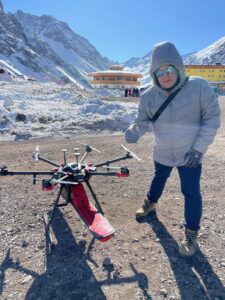
Drone Matrice 600 with Subecho 70 at Portillo border between Chile and Argentina
For example, GPR signals exposed to clay and saline soils are affected, therefore the results of a GPR scan in these types of areas have to be subjected to post-processing techniques that guarantee the accuracy of the underground model. In 2018 Geodia Industries became a distributor of the Latvian company SPH which produces software and sensors for geophysical exploration and the necessary technologies to scale their operations.
“In early 2020 we were ready to launch our newly developed technologies when the COVID-19 pandemic hit our principal markets and threw a wrench in our expansion plans,” Negrette said. “We held on to our drones and our key personnel and weathered the storm the best we could, and soon we were back on the field using our equipment. Soon our customers realized the obvious advantages of using drones to expedite jobs and save time and money, and we expanded our portfolio to include pipeline and manhole detection, structural geological analysis, aquifer allocation, leakage evaluation, and many more.”
With the insatiable appetite of humanity for natural resources, new exploration fronts are opened almost daily, and Negrette and his team’s services are required all over the world. When we asked about potential for growth, he was adamant that the potential is infinite.
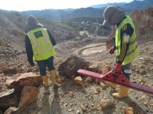
Ground GPR Survey at Mining Facility Mexico
“There’s a combination of new exploration and recurring services,” he said. “We, at Geodia, do both. On the one hand, we are required to perform scans of entirely new areas in hostile jungles in South America where the conditions to setup the technology are extremely challenging, and on the other hand, we have to do repetitive work in open pit mines in the driest desert on Earth every week. We do bathymetry and scanning of tailings storage facilities as we measure depth, humidity, and moisture studies to avoid disasters. It’s all in the life of a geoexploration company using uncrewed aviation.”
When probed about the specific equipment that they use in their daily flights, Negrette was more than specific.
Drone MT1500 and GPR Modelo Subecho 40 in Malaysia
“We use a DJI Matrice 600 Pro equipped with a Radarteam SubEcho-70 antenna to perform even the most challenging flights,” he said. “But the real work is done before and after the flight. We conduct extensive simulations in our materials laboratory where we create the conditions that would allow us, after the flight, to reconstruct the model of the terrain we are working on.”
With experiences like the one from Negrette and his team at Geodia, we can rest assured that geophysical and geological exploration with drones is here to stay in a time when the mining industry is experiencing explosive growth, as we explore new sources of renewable energy, and exploit every drop of existing oil reserves.
Juan B. Plaza is CEO of Plaza Aerospace, a drone and general aviation consulting firm specializing in modern uses for manned and unmanned aviation in mapping, lidar, and precision GNSS.