A forester’s guide to understanding lidar topics, from upfront data-acquisition costs to business benefits to the path from research to operationalization.
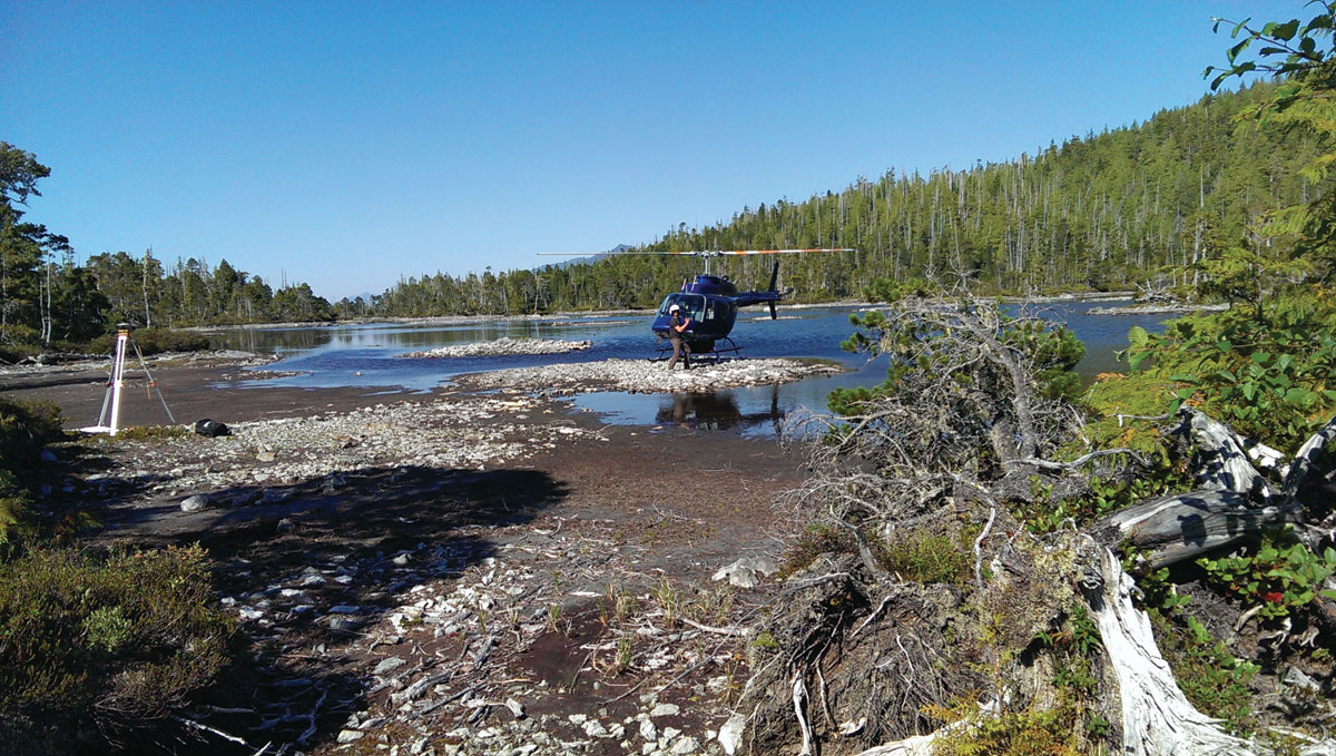
Using a helicopter allows Terra to set up GPS control points in a location that would not be accessable. This greatly increases the accuracy and efficiency of the survey.
Although many lidar industry insiders never imagined the day would come, lidar is quickly becoming a well-recognized acronym and highly coveted corporate asset in the forestry sector. While terrestrial and mobile lidar have demonstrated applications in forestry, it is airborne lidar that has received the greatest attention because of its ability to rapidly collect high-spatial-resolution terrain information (multiple points per square meter) over relatively large geographic areas (hundreds of thousands of acres).
Contrary to appearances, lidar is not a new technology; it’s been the subject of considerable international research interest and investment over the past three decades by the forest science community. However, the emergence of lidar as an operational tool in forest management in Canada (our home) has been far more recent than its technological viability. Adoption and integration of lidar into corporate and government operations has varied from small proof-of-concept studies to large, tenure-wide acquisitions and cross-organizational implementations.
The main impediment to the early adoption of lidar by forest companies has been the real or perceived upfront costs of data acquisition, as well as a lack of clear understanding of how this new source of spatially explicit terrain information can be used to benefit day-to-day company operations and overall competitiveness. Also, the pathway from research to operationalization is not straightforward and will vary according to the size and spatial configuration of the forestlands, forest and terrain conditions, and management goals.
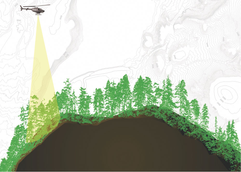
A 5m cross section of a lidar point cloud overlaid over DEM with a depiction of helicopter acquisition.
Preliminary findings from a few of the larger operational trials in British Columbia, Alberta, Ontario, and Newfoundland suggest that certain lidar-derived datasets and end-user applications provide a more immediate and larger return on investment than others. For example, a Digital Elevation Model (DEM) and Canopy Height Model (CHM) are easily extracted from a classified lidar point cloud and readily used in harvest planning and engineering applications. Lidar-enhanced forest inventories, on the other hand, require further investment and longer timelines to implement but can provide unparalleled precision and spatial detail for short and long-term resource planning.
Lidar, however, is not a “magic wand,” and it must be implemented with considerable thought and care to garner the best chance of success and greatest economic benefit. The cost-benefit of lidar will inevitably vary from project to project, depending on company circumstances (i.e., timber value, size and distribution of timberlands, climate, terrain, etc.) and the company’s ability to embrace, guide, and capitalize on technological change.
Here we offer ten guiding principles—thoughts, suggestions, and even commandments!—that may help companies presently thinking about adopting a lidar program or may provide additional insight for those already in transition and contemplating a larger and more challenging data-acquisition program.
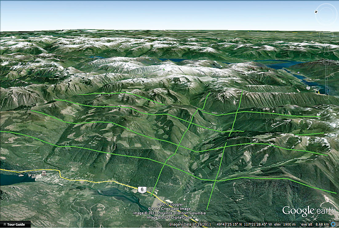
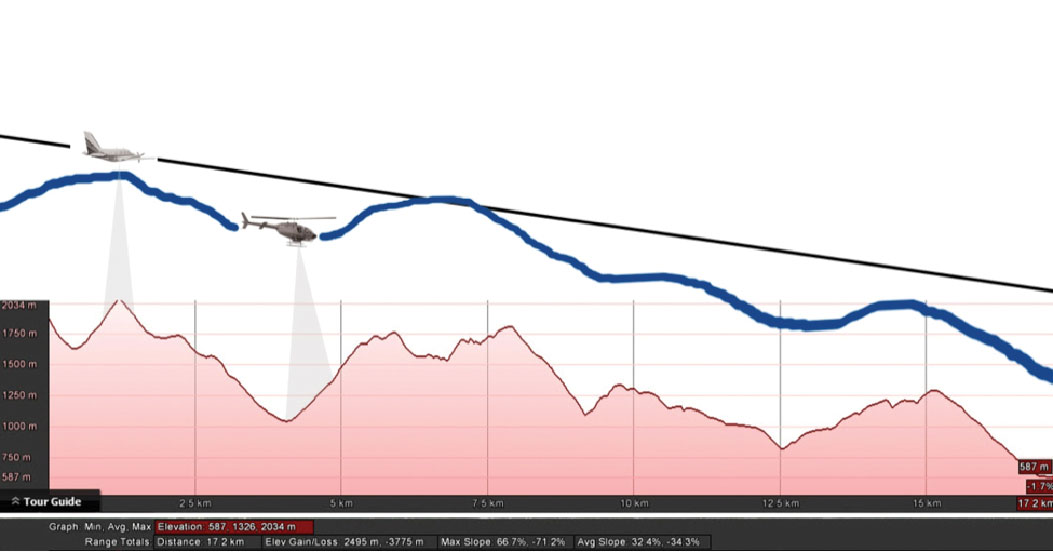
Typical flight plan for a forestry project in the Pacific Northwest. The upper lines are not broken; they are obscured by the ridge lines.
Recognize lidar’s opportunities, challenges, and limitations.
Lidar cannot penetrate solid objects, such as foliage or wood, and must find gaps in the forest canopy for a laser pulse to reach the ground. It does not directly measure forest inventory attributes, such as diameter, basal area, volume, or biomass, and datasets require independent calibration using a network of ground-reference plots to extract this information. Lidar will not give you species composition or wood quality (at least not yet), nor will it eliminate the need for skilled forestry professionals or “boots on the ground.”
Lidar can, however, provide unique kinds of spatially contiguous terrain information (i.e., canopy height, cover, and bare-earth topography) required by inventory specialists, engineers, and forest managers to make informed decisions on resource use and sustainability.
Know explicitly how lidar will be used to achieve key management goals.
Helicopters are a much better platform to collect lidar data in rugged terrain. Maintaining consistent elevation above the terrain produces more consistent and uniform point distribution.
The upfront costs of lidar can be large, so it is essential that companies understand how this technology will be used to improve operational performance in both the short and long terms. Small-scale operational trials can be beneficial in this regard, allowing companies to evaluate the potential cost-benefit of lidar and to better anticipate the challenges and opportunities associated with full-scale deployment.
While much can also be learned from external trials completed elsewhere, it may be prudent to acknowledge that certain cost-benefits will be project-specific and may not be readily applicable everywhere.
Find skilled professionals with relevant experience.
Lidar datasets can be both large and complex, and successful integration of these data within any organization will depend on the coordinated efforts of several skilled and experienced lidar specialists. The lidar data provider is at the critical front end of the production chain, and all subsequent processing and analytical work will depend on the overall quality and integrity of the delivered data.
Lidar analysts, application specialists, and biometricians will be responsible for the creation and delivery of more specialized, value-added data layers, which ultimately become integrated directly into the workflows of operational staff.
Understand the real costs of data acquisition and processing.
Airborne lidar sensors are very expensive to purchase, maintain, and operate, and datasets require extensive preprocessing and quality control before they can be delivered to the client. Nevertheless, lidar data costs continue to trend lower as technology becomes cheaper and the demand for services and competition in the marketplace rises. Prices, however, will vary across North America due to regional differences in weather, terrain, remoteness, and forest type.
In general, expect to pay between $3 and $10 per hectare in British Columbia, with costs dependent on total project area, location, schedule, platform (rotary vs. fixed-wing), minimum point density, and requested deliverables. Apparent bargains do exist, although remember to pay heed to that age-old proverb, “you get what you pay for.”
Seek out cost-sharing opportunities.
Lidar data-acquisition costs will decline on a per-hectare basis as the total project area increases. This is due to the high fixed costs associated with lidar mission planning and mobilization. Therefore, one way to achieve a better economy of scale with lidar is to pursue alliances or partnerships with adjacent or nearby stakeholders to collectively expand the total size of the project area.
Cost-sharing agreements may or may not include final data products, but this may be worth considering, too, if confidentiality is not an issue or can be incorporated into the agreement.
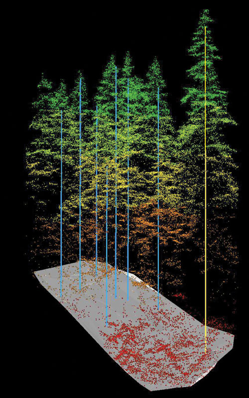
This lidar point cloud (colored by elevation with ground sample plots overlaid) depicts the capability of lidar to penetrate the forest canopy to model both forest structure and the “bare earth” surface. Credit: the University of Victoria.
Develop a comprehensive lidar-acquisition plan well in advance of the flying season.
Lidar data acquisition is constrained by local weather and near-ground atmospheric conditions, which often means short, sporadic, seasonal windows of opportunity for data collection, especially for more remote coastal and mountainous regions. The only way to guarantee successful data capture is to make sure that flight plans, survey specifications, and pricing are negotiated well in advance of the flying season.
Contract an experienced data provider with a proven track record.
Not all lidar datasets are created equal, and few if any will be error-free. Identifying skilled, experienced, and knowledgeable lidar data providers who are willing to work closely with the client is the key to surviving any difficulties that might arise while transitioning to a new technology.
Get basic data products into the hands of the end user as soon as possible.
Return on investment will be far more immediate if basic lidar data products are placed in the hands of the end user as quickly as possible. The DEM and CHM, for example, are two common data products delivered by the lidar data provider with high end-user value and should be distributed to planning and engineering departments for immediate use. Other more complex, value-added data products can be integrated as they become available.
For large acquisitions, be sure to work closely with your lidar data provider and technical specialists to match the delivery schedule with the data uptake rate. This is the only way to avoid the frustration of production bottlenecks.
Form partnerships when you pursue more risky R&D efforts.
For outcomes with unknown value, consider seeking outside partnerships to share risk and reward. The application of lidar in forestry is still evolving and will require continued investment by industry to further develop its use. There may be several opportunities to gain R&D support through universities, government institutions, and funding programs or through partnerships with other private sector companies.
Embrace and nurture technological change.
The success of any lidar program will depend on an organization’s ability to utilize and embrace new technology. The full integration of lidar into company operations will require change in the ways things were previously done, and support by staff and management will be critical during the period of transition. Lidar-derived data products, such as the DEM or CHM, are no different than other common GIS layers other than that they have unparalleled spatial accuracy and spatial detail. Experience, so far, indicates that planners and engineers work easily with lidar data products, and many have shown reluctance in returning to traditional sources once exposed to lidar data.
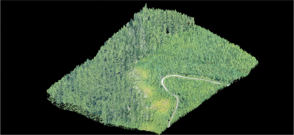
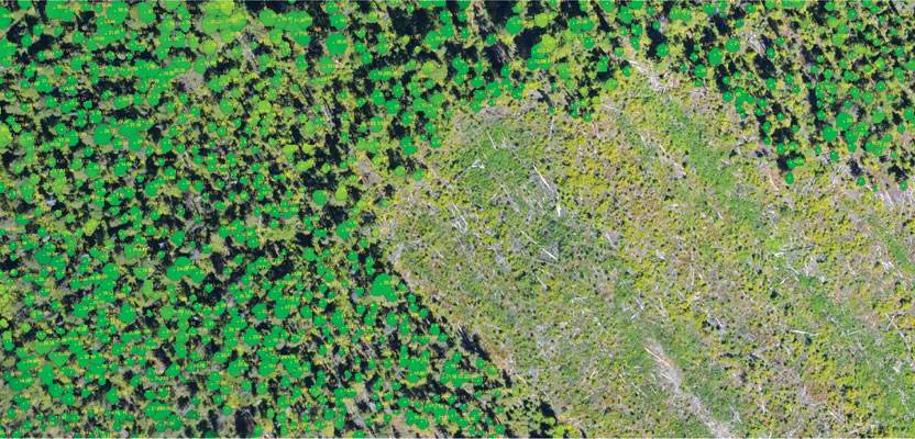
RGB colorized lidar point cloud
The business case for airborne lidar in forestry is not yet complete, but it is gradually unfolding as more companies and government agencies invest in operational trials across North America. Lidar data are intrinsically information-rich due to their high spatial resolution and precise 3D geometry. As a result, this technology may one day serve the multiple and diverse information needs of a single forestry organization (i.e., inventory, growth and yield, silviculture, harvest planning, engineering, and environmental).
There has been remarkable progress made in recent years to operationalize lidar, thanks to industry innovators and early adopters, and through industry-government R&D partnerships. However, continued innovation through investment by industry and government will be necessary to realize the full potential of lidar in the forest sector and to finally transfer this technology from the once-exclusive domain of forest scientists and firmly into the hands of today’s professional forester.